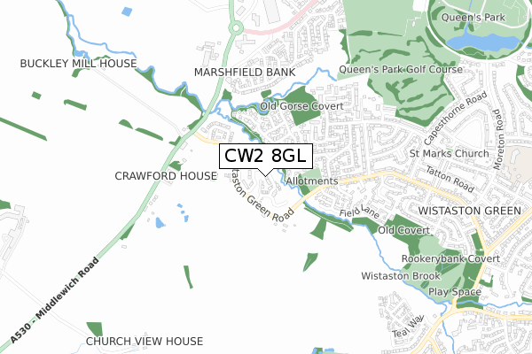
CW2 8GL is located in the Wistaston electoral ward, within the unitary authority of Cheshire East and the English Parliamentary constituency of Crewe and Nantwich. The Sub Integrated Care Board (ICB) Location is NHS Cheshire and Merseyside ICB - 27D and the police force is Cheshire. This postcode has been in use since July 2019.


GetTheData
Source: OS Open Zoomstack (Ordnance Survey)
Licence: Open Government Licence (requires attribution)
Attribution: Contains OS data © Crown copyright and database right 2025
Source: Open Postcode Geo
Licence: Open Government Licence (requires attribution)
Attribution: Contains OS data © Crown copyright and database right 2025; Contains Royal Mail data © Royal Mail copyright and database right 2025; Source: Office for National Statistics licensed under the Open Government Licence v.3.0
| Easting | 367729 |
| Northing | 354857 |
| Latitude | 53.089959 |
| Longitude | -2.483305 |
GetTheData
Source: Open Postcode Geo
Licence: Open Government Licence
| Country | England |
| Postcode District | CW2 |
➜ See where CW2 is on a map ➜ Where is Crewe? | |
GetTheData
Source: Land Registry Price Paid Data
Licence: Open Government Licence
| Ward | Wistaston |
| Constituency | Crewe And Nantwich |
GetTheData
Source: ONS Postcode Database
Licence: Open Government Licence
2024 23 FEB £240,000 |
2023 1 DEC £247,500 |
2023 31 OCT £250,000 |
2022 9 AUG £260,000 |
2022 3 MAR £235,500 |
2022 11 FEB £231,000 |
2021 20 DEC £225,000 |
2021 17 DEC £230,000 |
2021 26 NOV £230,000 |
2021 30 JUL £225,000 |
GetTheData
Source: HM Land Registry Price Paid Data
Licence: Contains HM Land Registry data © Crown copyright and database right 2025. This data is licensed under the Open Government Licence v3.0.
| The Rising Sun (Middlewich Road) | Wistaston | 479m |
| The Rising Sun (Middlewich Road) | Wistaston | 494m |
| Motorsave Direct (Middlewich Road) | Marshfield Bank | 517m |
| Houses (Nantwich Road) | Wistaston | 569m |
| The Beefeater (Coppenhall Lane) | Woolstanwood | 701m |
| Crewe Station | 3.4km |
| Nantwich Station | 3.8km |
GetTheData
Source: NaPTAN
Licence: Open Government Licence
| Percentage of properties with Next Generation Access | 100.0% |
| Percentage of properties with Superfast Broadband | 100.0% |
| Percentage of properties with Ultrafast Broadband | 100.0% |
| Percentage of properties with Full Fibre Broadband | 100.0% |
Superfast Broadband is between 30Mbps and 300Mbps
Ultrafast Broadband is > 300Mbps
| Percentage of properties unable to receive 2Mbps | 0.0% |
| Percentage of properties unable to receive 5Mbps | 0.0% |
| Percentage of properties unable to receive 10Mbps | 0.0% |
| Percentage of properties unable to receive 30Mbps | 0.0% |
GetTheData
Source: Ofcom
Licence: Ofcom Terms of Use (requires attribution)
GetTheData
Source: ONS Postcode Database
Licence: Open Government Licence


➜ Get more ratings from the Food Standards Agency
GetTheData
Source: Food Standards Agency
Licence: FSA terms & conditions
| Last Collection | |||
|---|---|---|---|
| Location | Mon-Fri | Sat | Distance |
| Alvaston | 16:45 | 08:30 | 613m |
| Wistaston Green Road | 17:30 | 12:30 | 781m |
| Aldersey Road | 17:15 | 12:30 | 1,133m |
GetTheData
Source: Dracos
Licence: Creative Commons Attribution-ShareAlike
The below table lists the International Territorial Level (ITL) codes (formerly Nomenclature of Territorial Units for Statistics (NUTS) codes) and Local Administrative Units (LAU) codes for CW2 8GL:
| ITL 1 Code | Name |
|---|---|
| TLD | North West (England) |
| ITL 2 Code | Name |
| TLD6 | Cheshire |
| ITL 3 Code | Name |
| TLD62 | Cheshire East |
| LAU 1 Code | Name |
| E06000049 | Cheshire East |
GetTheData
Source: ONS Postcode Directory
Licence: Open Government Licence
The below table lists the Census Output Area (OA), Lower Layer Super Output Area (LSOA), and Middle Layer Super Output Area (MSOA) for CW2 8GL:
| Code | Name | |
|---|---|---|
| OA | E00093418 | |
| LSOA | E01018510 | Cheshire East 044A |
| MSOA | E02003833 | Cheshire East 044 |
GetTheData
Source: ONS Postcode Directory
Licence: Open Government Licence
| CW2 8NY | Grizedale Close | 138m |
| CW2 8SA | Wistaston Green Road | 167m |
| CW2 8RS | Langdale Road | 208m |
| CW2 8QF | Riverside Grove | 259m |
| CW2 8NX | Patterdale Close | 263m |
| CW2 8QE | Glendale Close | 275m |
| CW2 8RH | Windermere Road | 277m |
| CW2 8SS | Field Lane | 286m |
| CW2 8RY | Bowness Road | 318m |
| CW2 8RZ | Borrowdale Close | 367m |
GetTheData
Source: Open Postcode Geo; Land Registry Price Paid Data
Licence: Open Government Licence