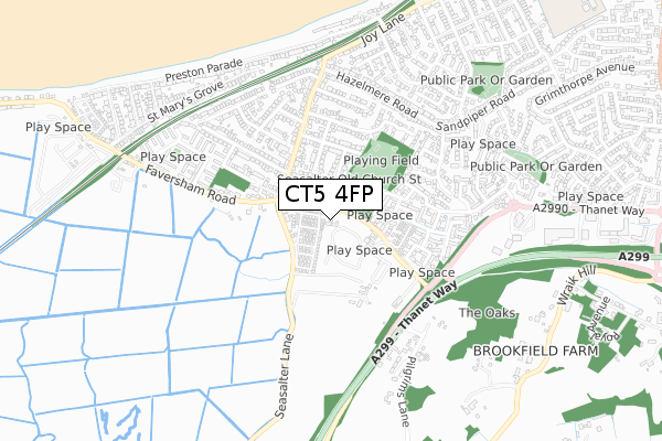
CT5 4FP maps, stats, and open data
CT5 4FP is located in the Seasalter electoral ward, within the local authority district of Canterbury and the English Parliamentary constituency of Canterbury. The Sub Integrated Care Board (ICB) Location is NHS Kent and Medway ICB - 91Q and the police force is Kent. This postcode has been in use since March 2019.
CT5 4FP maps


Licence: Open Government Licence (requires attribution)
Attribution: Contains OS data © Crown copyright and database right 2025
Source: Open Postcode Geo
Licence: Open Government Licence (requires attribution)
Attribution: Contains OS data © Crown copyright and database right 2025; Contains Royal Mail data © Royal Mail copyright and database right 2025; Source: Office for National Statistics licensed under the Open Government Licence v.3.0
CT5 4FP geodata
| Easting | 609248 |
| Northing | 164589 |
| Latitude | 51.341862 |
| Longitude | 1.003019 |
Where is CT5 4FP?
| Country | England |
| Postcode District | CT5 |
Politics
| Ward | Seasalter |
|---|---|
| Constituency | Canterbury |
House Prices
Sales of detached houses in CT5 4FP
LITTLE OAKS, CHURCH COURT, SEASALTER, WHITSTABLE, CT5 4FP 2022 27 OCT £544,000 |
TANGLEWOOD, CHURCH COURT, SEASALTER, WHITSTABLE, CT5 4FP 2021 28 APR £585,000 |
LITTLE OAKS, CHURCH COURT, SEASALTER, WHITSTABLE, CT5 4FP 2021 12 APR £494,000 |
THE WILLOWS, CHURCH COURT, SEASALTER, WHITSTABLE, CT5 4FP 2021 31 MAR £727,000 |
TANGLEWOOD, CHURCH COURT, SEASALTER, WHITSTABLE, CT5 4FP 2016 27 MAY £350,000 |
TANGLEWOOD, CHURCH COURT, SEASALTER, WHITSTABLE, CT5 4FP 2001 1 AUG £110,000 |
Licence: Contains HM Land Registry data © Crown copyright and database right 2025. This data is licensed under the Open Government Licence v3.0.
Transport
Nearest bus stops to CT5 4FP
| Seasalter Cross (Faversham Road) | Seasalter | 209m |
| Seasalter Cross (Faversham Road) | Seasalter | 226m |
| Eden Road (Faversham Road) | Seasalter | 474m |
| Eden Road (Faversham Road) | Seasalter | 489m |
| Lucerne Drive East (Lucerne Drive) | Seasalter | 528m |
Nearest railway stations to CT5 4FP
| Whitstable Station | 2.7km |
| Chestfield & Swalecliffe Station | 4.9km |
Broadband
Broadband access in CT5 4FP (2020 data)
| Percentage of properties with Next Generation Access | 100.0% |
| Percentage of properties with Superfast Broadband | 100.0% |
| Percentage of properties with Ultrafast Broadband | 0.0% |
| Percentage of properties with Full Fibre Broadband | 0.0% |
Superfast Broadband is between 30Mbps and 300Mbps
Ultrafast Broadband is > 300Mbps
Broadband limitations in CT5 4FP (2020 data)
| Percentage of properties unable to receive 2Mbps | 0.0% |
| Percentage of properties unable to receive 5Mbps | 0.0% |
| Percentage of properties unable to receive 10Mbps | 0.0% |
| Percentage of properties unable to receive 30Mbps | 0.0% |
Deprivation
29.2% of English postcodes are less deprived than CT5 4FP:Food Standards Agency
Three nearest food hygiene ratings to CT5 4FP (metres)


➜ Get more ratings from the Food Standards Agency
Nearest post box to CT5 4FP
| Last Collection | |||
|---|---|---|---|
| Location | Mon-Fri | Sat | Distance |
| Seasalter Cross | 16:00 | 11:45 | 275m |
| Columbia Avenue | 17:00 | 11:45 | 625m |
| Speedwell Road | 16:00 | 10:30 | 671m |
CT5 4FP ITL and CT5 4FP LAU
The below table lists the International Territorial Level (ITL) codes (formerly Nomenclature of Territorial Units for Statistics (NUTS) codes) and Local Administrative Units (LAU) codes for CT5 4FP:
| ITL 1 Code | Name |
|---|---|
| TLJ | South East (England) |
| ITL 2 Code | Name |
| TLJ4 | Kent |
| ITL 3 Code | Name |
| TLJ44 | East Kent |
| LAU 1 Code | Name |
| E07000106 | Canterbury |
CT5 4FP census areas
The below table lists the Census Output Area (OA), Lower Layer Super Output Area (LSOA), and Middle Layer Super Output Area (MSOA) for CT5 4FP:
| Code | Name | |
|---|---|---|
| OA | E00167522 | |
| LSOA | E01024109 | Canterbury 009E |
| MSOA | E02005018 | Canterbury 009 |
Nearest postcodes to CT5 4FP
| CT5 4QG | Heritage Close | 101m |
| CT5 4BX | Church Lane | 146m |
| CT5 4BS | Seasalter Lane | 165m |
| CT5 4BB | Freemans Close | 181m |
| CT5 4ST | St Margarets Close | 202m |
| CT5 4UF | Portlight Place | 208m |
| CT5 4BD | Faversham Road | 232m |
| CT5 4SS | Chanctonbury Chase | 256m |
| CT5 4AX | Faversham Road | 257m |
| CT5 4BU | Church Lane | 258m |