CO9 2FR maps, stats, and open data
CO9 2FR is located in the Halstead St Andrew's electoral ward, within the local authority district of Braintree and the English Parliamentary constituency of Braintree. The Sub Integrated Care Board (ICB) Location is NHS Mid and South Essex ICB - 06Q and the police force is Essex. This postcode has been in use since June 2018.
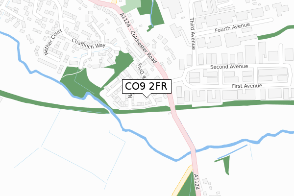
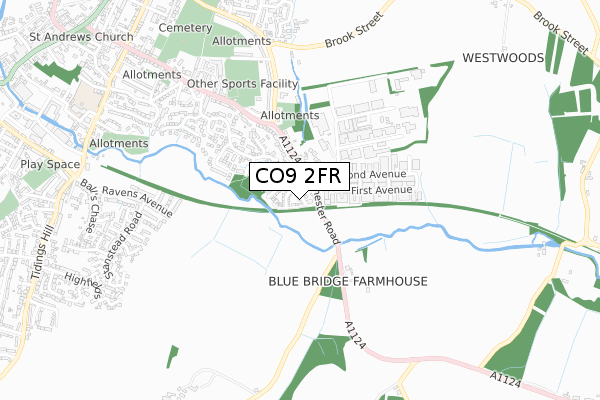
CO9 2FR maps


Licence: Open Government Licence (requires attribution)
Attribution: Contains OS data © Crown copyright and database right 2025
Source: Open Postcode Geo
Licence: Open Government Licence (requires attribution)
Attribution: Contains OS data © Crown copyright and database right 2025; Contains Royal Mail data © Royal Mail copyright and database right 2025; Source: Office for National Statistics licensed under the Open Government Licence v.3.0
CO9 2FR geodata
| Easting | 582448 |
| Northing | 230006 |
| Latitude | 51.938653 |
| Longitude | 0.652777 |
Where is CO9 2FR?
| Country | England |
| Postcode District | CO9 |
Politics
| Ward | Halstead St Andrew's |
|---|---|
| Constituency | Braintree |
House Prices
Sales of detached houses in CO9 2FR
22, STARLING CLOSE, HALSTEAD, CO9 2FR 2019 12 SEP £314,995 |
1, STARLING CLOSE, HALSTEAD, CO9 2FR 2018 31 MAY £309,995 |
Licence: Contains HM Land Registry data © Crown copyright and database right 2025. This data is licensed under the Open Government Licence v3.0.
Transport
Nearest bus stops to CO9 2FR
| Blue Bridge (Colchester Road) | Halstead | 157m |
| Blue Bridge (Colchester Road) | Halstead | 157m |
| Fenn Road | Halstead | 414m |
| Courtauld Playing Fields (Colchester Road) | Halstead | 446m |
| Courtauld Playing Fields (Colchester Road) | Halstead | 488m |
Broadband
Broadband access in CO9 2FR (2020 data)
| Percentage of properties with Next Generation Access | 100.0% |
| Percentage of properties with Superfast Broadband | 100.0% |
| Percentage of properties with Ultrafast Broadband | 100.0% |
| Percentage of properties with Full Fibre Broadband | 100.0% |
Superfast Broadband is between 30Mbps and 300Mbps
Ultrafast Broadband is > 300Mbps
Broadband limitations in CO9 2FR (2020 data)
| Percentage of properties unable to receive 2Mbps | 0.0% |
| Percentage of properties unable to receive 5Mbps | 0.0% |
| Percentage of properties unable to receive 10Mbps | 0.0% |
| Percentage of properties unable to receive 30Mbps | 0.0% |
Deprivation
27.9% of English postcodes are less deprived than CO9 2FR:Food Standards Agency
Three nearest food hygiene ratings to CO9 2FR (metres)


➜ Get more ratings from the Food Standards Agency
Nearest post box to CO9 2FR
| Last Collection | |||
|---|---|---|---|
| Location | Mon-Fri | Sat | Distance |
| Bluebridge Industrial Estate | 17:30 | 11:45 | 121m |
| Elm Drive | 17:00 | 11:45 | 836m |
| Bentall Close Highfields | 17:00 | 11:45 | 933m |
CO9 2FR ITL and CO9 2FR LAU
The below table lists the International Territorial Level (ITL) codes (formerly Nomenclature of Territorial Units for Statistics (NUTS) codes) and Local Administrative Units (LAU) codes for CO9 2FR:
| ITL 1 Code | Name |
|---|---|
| TLH | East |
| ITL 2 Code | Name |
| TLH3 | Essex |
| ITL 3 Code | Name |
| TLH34 | Essex Haven Gateway |
| LAU 1 Code | Name |
| E07000067 | Braintree |
CO9 2FR census areas
The below table lists the Census Output Area (OA), Lower Layer Super Output Area (LSOA), and Middle Layer Super Output Area (MSOA) for CO9 2FR:
| Code | Name | |
|---|---|---|
| OA | E00108633 | |
| LSOA | E01021389 | Braintree 006A |
| MSOA | E02004451 | Braintree 006 |
Nearest postcodes to CO9 2FR
| CO9 2ST | Brook Farm Close | 183m |
| CO9 2EU | Colchester Road | 190m |
| CO9 2HD | Colchester Road | 213m |
| CO9 2GZ | Bullfinch Drive | 234m |
| CO9 2HW | Chaffinch Way | 247m |
| CO9 2HB | Larks Rise | 292m |
| CO9 2SU | Second Avenue | 305m |
| CO9 2EX | First Avenue | 319m |
| CO9 2HN | Nether Court | 359m |
| CO9 1QG | Colchester Road | 382m |