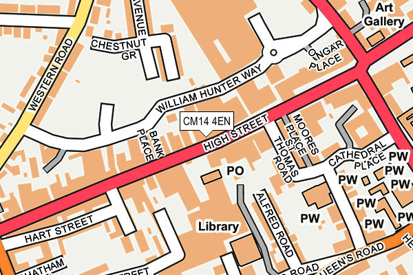
CM14 4EN is located in the Brentwood North electoral ward, within the local authority district of Brentwood and the English Parliamentary constituency of Brentwood and Ongar. The Sub Integrated Care Board (ICB) Location is NHS Mid and South Essex ICB - 99E and the police force is Essex. This postcode has been in use since April 2018.


GetTheData
Source: OS OpenMap – Local (Ordnance Survey)
Source: OS VectorMap District (Ordnance Survey)
Licence: Open Government Licence (requires attribution)
| Easting | 559485 |
| Northing | 193802 |
| Latitude | 51.620449 |
| Longitude | 0.302415 |
GetTheData
Source: Open Postcode Geo
Licence: Open Government Licence
| Country | England |
| Postcode District | CM14 |
➜ See where CM14 is on a map ➜ Where is Brentwood? | |
GetTheData
Source: Land Registry Price Paid Data
Licence: Open Government Licence
| Ward | Brentwood North |
| Constituency | Brentwood And Ongar |
GetTheData
Source: ONS Postcode Database
Licence: Open Government Licence
| High Street | Brentwood | 147m |
| High Street | Brentwood | 157m |
| High Street | Brentwood | 159m |
| High Street | Brentwood | 178m |
| Sainsburys (William Hunter Way) | Brentwood | 185m |
| Brentwood Station | 0.8km |
| Shenfield Station | 2.2km |
| Harold Wood Station | 5.7km |
GetTheData
Source: NaPTAN
Licence: Open Government Licence
| Percentage of properties with Next Generation Access | 50.0% |
| Percentage of properties with Superfast Broadband | 50.0% |
| Percentage of properties with Ultrafast Broadband | 0.0% |
| Percentage of properties with Full Fibre Broadband | 0.0% |
Superfast Broadband is between 30Mbps and 300Mbps
Ultrafast Broadband is > 300Mbps
| Percentage of properties unable to receive 2Mbps | 0.0% |
| Percentage of properties unable to receive 5Mbps | 0.0% |
| Percentage of properties unable to receive 10Mbps | 0.0% |
| Percentage of properties unable to receive 30Mbps | 50.0% |
GetTheData
Source: Ofcom
Licence: Ofcom Terms of Use (requires attribution)
GetTheData
Source: ONS Postcode Database
Licence: Open Government Licence


➜ Get more ratings from the Food Standards Agency
GetTheData
Source: Food Standards Agency
Licence: FSA terms & conditions
| Last Collection | |||
|---|---|---|---|
| Location | Mon-Fri | Sat | Distance |
| Brentwood Post Office | 18:30 | 12:30 | 127m |
| Western Road | 17:15 | 08:10 | 238m |
| Crown Street | 17:30 | 09:00 | 248m |
GetTheData
Source: Dracos
Licence: Creative Commons Attribution-ShareAlike
The below table lists the International Territorial Level (ITL) codes (formerly Nomenclature of Territorial Units for Statistics (NUTS) codes) and Local Administrative Units (LAU) codes for CM14 4EN:
| ITL 1 Code | Name |
|---|---|
| TLH | East |
| ITL 2 Code | Name |
| TLH3 | Essex |
| ITL 3 Code | Name |
| TLH36 | Heart of Essex |
| LAU 1 Code | Name |
| E07000068 | Brentwood |
GetTheData
Source: ONS Postcode Directory
Licence: Open Government Licence
The below table lists the Census Output Area (OA), Lower Layer Super Output Area (LSOA), and Middle Layer Super Output Area (MSOA) for CM14 4EN:
| Code | Name | |
|---|---|---|
| OA | E00108878 | |
| LSOA | E01021433 | Brentwood 007A |
| MSOA | E02004470 | Brentwood 007 |
GetTheData
Source: ONS Postcode Directory
Licence: Open Government Licence
| CM14 4RW | High Street | 30m |
| CM14 4AJ | High Street | 38m |
| CM14 4RH | High Street | 53m |
| CM14 4RP | High Street | 79m |
| CM14 4AN | High Street | 95m |
| CM14 4BX | Baytree Centre | 100m |
| CM14 4EB | St Thomas Road | 114m |
| CM14 4RR | High Street | 125m |
| CM14 4XN | North Road Avenue | 130m |
| CM14 4DB | St Thomas Road | 136m |
GetTheData
Source: Open Postcode Geo; Land Registry Price Paid Data
Licence: Open Government Licence