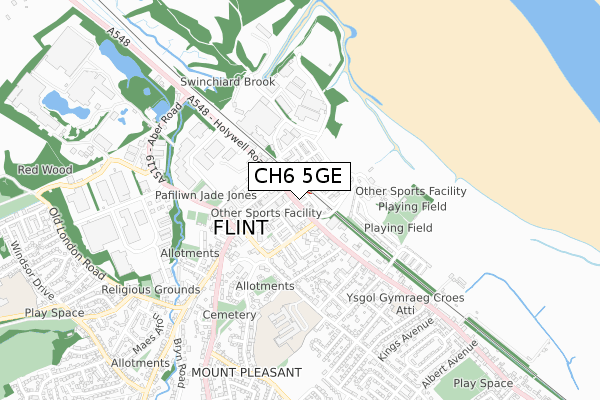
CH6 5GE is located in the Flint: Castle electoral ward, within the unitary authority of Flintshire and the Welsh Parliamentary constituency of Delyn. The Local Health Board is Betsi Cadwaladr University and the police force is North Wales. This postcode has been in use since January 2018.


GetTheData
Source: OS Open Zoomstack (Ordnance Survey)
Licence: Open Government Licence (requires attribution)
Attribution: Contains OS data © Crown copyright and database right 2025
Source: Open Postcode Geo
Licence: Open Government Licence (requires attribution)
Attribution: Contains OS data © Crown copyright and database right 2025; Contains Royal Mail data © Royal Mail copyright and database right 2025; Source: Office for National Statistics licensed under the Open Government Licence v.3.0
| Easting | 324510 |
| Northing | 373079 |
| Latitude | 53.249351 |
| Longitude | -3.132838 |
GetTheData
Source: Open Postcode Geo
Licence: Open Government Licence
| Country | Wales |
| Postcode District | CH6 |
➜ See where CH6 is on a map ➜ Where is Flint? | |
GetTheData
Source: Land Registry Price Paid Data
Licence: Open Government Licence
| Ward | Flint: Castle |
| Constituency | Delyn |
GetTheData
Source: ONS Postcode Database
Licence: Open Government Licence
| Swan Hotel (Chester Street) | Flint | 105m |
| Ship (Holywell Street) | Flint | 154m |
| Swan Hotel (Chester Street) | Flint | 206m |
| Mcdonalds (Holywell Street) | Flint | 221m |
| Library (Church Street) | Flint | 232m |
| Flint Station | 0km |
| Neston Station | 6.6km |
GetTheData
Source: NaPTAN
Licence: Open Government Licence
| Percentage of properties with Next Generation Access | 100.0% |
| Percentage of properties with Superfast Broadband | 100.0% |
| Percentage of properties with Ultrafast Broadband | 0.0% |
| Percentage of properties with Full Fibre Broadband | 0.0% |
Superfast Broadband is between 30Mbps and 300Mbps
Ultrafast Broadband is > 300Mbps
| Percentage of properties unable to receive 2Mbps | 0.0% |
| Percentage of properties unable to receive 5Mbps | 0.0% |
| Percentage of properties unable to receive 10Mbps | 0.0% |
| Percentage of properties unable to receive 30Mbps | 0.0% |
GetTheData
Source: Ofcom
Licence: Ofcom Terms of Use (requires attribution)
GetTheData
Source: ONS Postcode Database
Licence: Open Government Licence


➜ Get more ratings from the Food Standards Agency
GetTheData
Source: Food Standards Agency
Licence: FSA terms & conditions
| Last Collection | |||
|---|---|---|---|
| Location | Mon-Fri | Sat | Distance |
| Flint Main Post Office | 17:30 | 11:30 | 226m |
| Earl Street | 17:01 | 07:00 | 291m |
| Halkyn Street | 16:17 | 07:00 | 448m |
GetTheData
Source: Dracos
Licence: Creative Commons Attribution-ShareAlike
The below table lists the International Territorial Level (ITL) codes (formerly Nomenclature of Territorial Units for Statistics (NUTS) codes) and Local Administrative Units (LAU) codes for CH6 5GE:
| ITL 1 Code | Name |
|---|---|
| TLL | Wales |
| ITL 2 Code | Name |
| TLL2 | East Wales |
| ITL 3 Code | Name |
| TLL23 | Flintshire and Wrexham |
| LAU 1 Code | Name |
| W06000005 | Flintshire |
GetTheData
Source: ONS Postcode Directory
Licence: Open Government Licence
The below table lists the Census Output Area (OA), Lower Layer Super Output Area (LSOA), and Middle Layer Super Output Area (MSOA) for CH6 5GE:
| Code | Name | |
|---|---|---|
| OA | W00001549 | |
| LSOA | W01000288 | Flintshire 004A |
| MSOA | W02000061 | Flintshire 004 |
GetTheData
Source: ONS Postcode Directory
Licence: Open Government Licence
| CH6 5NR | Chester Street | 44m |
| CH6 5BL | Chester Street | 45m |
| CH6 5NN | Trelawney Square | 46m |
| CH6 5NW | Market Square | 58m |
| CH6 5PG | Corporation Street | 96m |
| CH6 5LA | Sydney Walk | 100m |
| CH6 5AD | Church Street | 112m |
| CH6 5BP | Swan Street | 113m |
| CH6 5PF | Castle Street | 132m |
| CH6 5PQ | New Roskell Square | 136m |
GetTheData
Source: Open Postcode Geo; Land Registry Price Paid Data
Licence: Open Government Licence