Property/Postcode Data Search:
CF61 2AW maps, stats, and open data
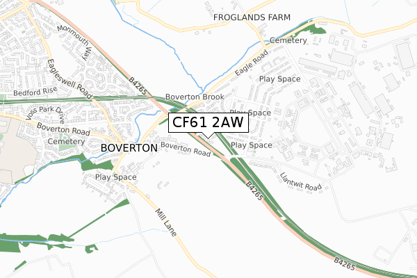
CF61 2AW is located in the Llantwit Major electoral ward, within the unitary authority of Vale of Glamorgan and the Welsh Parliamentary constituency of Vale of Glamorgan. The Local Health Board is Cardiff and Vale University and the police force is South Wales. This postcode has been in use since December 2019.
CF61 2AW maps


Source: OS Open Zoomstack (Ordnance Survey)
Licence: Open Government Licence (requires attribution)
Attribution: Contains OS data © Crown copyright and database right 2025
Source: Open Postcode Geo
Licence: Open Government Licence (requires attribution)
Attribution: Contains OS data © Crown copyright and database right 2025; Contains Royal Mail data © Royal Mail copyright and database right 2025; Source: Office for National Statistics licensed under the Open Government Licence v.3.0
Licence: Open Government Licence (requires attribution)
Attribution: Contains OS data © Crown copyright and database right 2025
Source: Open Postcode Geo
Licence: Open Government Licence (requires attribution)
Attribution: Contains OS data © Crown copyright and database right 2025; Contains Royal Mail data © Royal Mail copyright and database right 2025; Source: Office for National Statistics licensed under the Open Government Licence v.3.0
CF61 2AW geodata
| Easting | 298794 |
| Northing | 168447 |
| Latitude | 51.405988 |
| Longitude | -3.456434 |
Where is CF61 2AW?
| Country | Wales |
| Postcode District | CF61 |
Politics
| Ward | Llantwit Major |
|---|---|
| Constituency | Vale Of Glamorgan |
House Prices
Sales of detached houses in CF61 2AW
2023 8 DEC £260,000 |
2023 21 JUN £280,000 |
2021 28 MAY £248,995 |
12, SOUTH VIEW, BOVERTON, LLANTWIT MAJOR, CF61 2AW 2021 28 MAY £248,995 |
11, SOUTH VIEW, BOVERTON, LLANTWIT MAJOR, CF61 2AW 2021 30 APR £248,995 |
10, SOUTH VIEW, BOVERTON, LLANTWIT MAJOR, CF61 2AW 2021 30 APR £239,995 |
18, SOUTH VIEW, BOVERTON, LLANTWIT MAJOR, CF61 2AW 2021 26 MAR £240,995 |
2021 26 FEB £235,995 |
6, SOUTH VIEW, BOVERTON, LLANTWIT MAJOR, CF61 2AW 2020 10 DEC £526,995 |
5, SOUTH VIEW, BOVERTON, LLANTWIT MAJOR, CF61 2AW 2020 27 NOV £256,995 |
Source: HM Land Registry Price Paid Data
Licence: Contains HM Land Registry data © Crown copyright and database right 2025. This data is licensed under the Open Government Licence v3.0.
Licence: Contains HM Land Registry data © Crown copyright and database right 2025. This data is licensed under the Open Government Licence v3.0.
Transport
Nearest bus stops to CF61 2AW
| West Camp (B4265) | Boverton | 108m |
| West Camp (B4265) | Boverton | 125m |
| Starling Road | St Athan | 275m |
| Old Brewery (Eglwys Brewis Road) | Boverton | 281m |
| Old Brewery (Eglwys Brewis Road) | Boverton | 298m |
Nearest railway stations to CF61 2AW
| Llantwit Major Station | 1.8km |
Deprivation
22% of Welsh postcodes are less deprived than CF61 2AW:Food Standards Agency
Three nearest food hygiene ratings to CF61 2AW (metres)
Swallow Playgroup

Community Centre Starling Road
195m
The Boverton Castle

Boverton Castle Eagleswell Road
509m
Bargain Booze

Post Office Boverton Brook Shops
509m
➜ Get more ratings from the Food Standards Agency
Nearest post box to CF61 2AW
| Last Collection | |||
|---|---|---|---|
| Location | Mon-Fri | Sat | Distance |
| Boverton Post Office | 16:45 | 11:45 | 533m |
| Boverton Road | 16:45 | 11:15 | 1,715m |
| Colhugh Street | 16:45 | 11:15 | 1,985m |
CF61 2AW ITL and CF61 2AW LAU
The below table lists the International Territorial Level (ITL) codes (formerly Nomenclature of Territorial Units for Statistics (NUTS) codes) and Local Administrative Units (LAU) codes for CF61 2AW:
| ITL 1 Code | Name |
|---|---|
| TLL | Wales |
| ITL 2 Code | Name |
| TLL2 | East Wales |
| ITL 3 Code | Name |
| TLL22 | Cardiff and Vale of Glamorgan |
| LAU 1 Code | Name |
| W06000014 | Vale of Glamorgan |
CF61 2AW census areas
The below table lists the Census Output Area (OA), Lower Layer Super Output Area (LSOA), and Middle Layer Super Output Area (MSOA) for CF61 2AW:
| Code | Name | |
|---|---|---|
| OA | W00005847 | |
| LSOA | W01001108 | The Vale of Glamorgan 014A |
| MSOA | W02000250 | The Vale of Glamorgan 014 |
Nearest postcodes to CF61 2AW
| CF62 4NL | Blackbird Road | 125m |
| CF62 4NQ | Magpie Road | 194m |
| CF61 2AT | Church Meadow | 212m |
| CF62 4NJ | Starling Road | 255m |
| CF61 1UZ | Orchard Close | 272m |
| CF61 1YN | Boverton Park Drive | 374m |
| CF62 4NF | Partridge Road | 398m |
| CF61 1UE | Boverton Park | 405m |
| CF62 4ND | Bullfinch Road | 471m |
| CF62 4NR | Eagle Road | 505m |