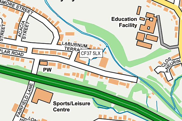
CF37 5LX is located in the Rhydfelen Central electoral ward, within the unitary authority of Rhondda Cynon Taf and the Welsh Parliamentary constituency of Pontypridd. The Local Health Board is Cwm Taf Morgannwg University and the police force is South Wales. This postcode has been in use since February 2017.


GetTheData
Source: OS OpenMap – Local (Ordnance Survey)
Source: OS VectorMap District (Ordnance Survey)
Licence: Open Government Licence (requires attribution)
| Easting | 309043 |
| Northing | 188188 |
| Latitude | 51.585182 |
| Longitude | -3.314222 |
GetTheData
Source: Open Postcode Geo
Licence: Open Government Licence
| Country | Wales |
| Postcode District | CF37 |
➜ See where CF37 is on a map ➜ Where is Pontypridd? | |
GetTheData
Source: Land Registry Price Paid Data
Licence: Open Government Licence
| Ward | Rhydfelen Central |
| Constituency | Pontypridd |
GetTheData
Source: ONS Postcode Database
Licence: Open Government Licence
| Library (Poplar Road) | Rhydyfelin | 17m |
| Library (Poplar Road) | Rhydyfelin | 23m |
| Post Office (Dyffryn Road) | Rhydyfelin | 92m |
| College Green (College Way) | Rhydyfelin | 112m |
| College Green (College Way) | Rhydyfelin | 130m |
| Trefforest Station | 1km |
| Pontypridd Station | 2.5km |
| Trefforest Estate Station | 2.5km |
GetTheData
Source: NaPTAN
Licence: Open Government Licence
| Percentage of properties with Next Generation Access | 100.0% |
| Percentage of properties with Superfast Broadband | 100.0% |
| Percentage of properties with Ultrafast Broadband | 100.0% |
| Percentage of properties with Full Fibre Broadband | 0.0% |
Superfast Broadband is between 30Mbps and 300Mbps
Ultrafast Broadband is > 300Mbps
| Median download speed | 40.0Mbps |
| Average download speed | 28.6Mbps |
| Maximum download speed | 55.00Mbps |
| Median upload speed | 10.0Mbps |
| Average upload speed | 7.4Mbps |
| Maximum upload speed | 18.69Mbps |
| Percentage of properties unable to receive 2Mbps | 0.0% |
| Percentage of properties unable to receive 5Mbps | 0.0% |
| Percentage of properties unable to receive 10Mbps | 0.0% |
| Percentage of properties unable to receive 30Mbps | 0.0% |
GetTheData
Source: Ofcom
Licence: Ofcom Terms of Use (requires attribution)
GetTheData
Source: ONS Postcode Database
Licence: Open Government Licence


➜ Get more ratings from the Food Standards Agency
GetTheData
Source: Food Standards Agency
Licence: FSA terms & conditions
| Last Collection | |||
|---|---|---|---|
| Location | Mon-Fri | Sat | Distance |
| Treforest | 17:30 | 12:00 | 1,192m |
| Glyntaff | 17:30 | 11:15 | 1,386m |
| Broadway | 17:45 | 11:15 | 1,560m |
GetTheData
Source: Dracos
Licence: Creative Commons Attribution-ShareAlike
The below table lists the International Territorial Level (ITL) codes (formerly Nomenclature of Territorial Units for Statistics (NUTS) codes) and Local Administrative Units (LAU) codes for CF37 5LX:
| ITL 1 Code | Name |
|---|---|
| TLL | Wales |
| ITL 2 Code | Name |
| TLL1 | West Wales and The Valleys |
| ITL 3 Code | Name |
| TLL15 | Central Valleys |
| LAU 1 Code | Name |
| W06000016 | Rhondda Cynon Taf |
GetTheData
Source: ONS Postcode Directory
Licence: Open Government Licence
The below table lists the Census Output Area (OA), Lower Layer Super Output Area (LSOA), and Middle Layer Super Output Area (MSOA) for CF37 5LX:
| Code | Name | |
|---|---|---|
| OA | W00006239 | |
| LSOA | W01001185 | Rhondda Cynon Taf 022A |
| MSOA | W02000273 | Rhondda Cynon Taf 022 |
GetTheData
Source: ONS Postcode Directory
Licence: Open Government Licence
| CF37 5RS | Warren Close | 67m |
| CF37 5NP | Ash Square | 89m |
| CF37 5NL | Willow Street | 104m |
| CF37 5RL | College Close | 132m |
| CF37 5RZ | Parc Y Dyffryn | 132m |
| CF37 5PX | Heol Gruffydd | 143m |
| CF37 5RH | Janet Street | 168m |
| CF37 5HP | Cardiff Road | 180m |
| CF37 5NN | Cypress Street | 182m |
| CF37 5NG | Chestnut Street | 191m |
GetTheData
Source: Open Postcode Geo; Land Registry Price Paid Data
Licence: Open Government Licence