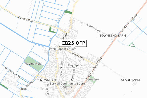
CB25 0FP maps, stats, and open data
CB25 0FP is located in the Burwell electoral ward, within the local authority district of East Cambridgeshire and the English Parliamentary constituency of South East Cambridgeshire. The Sub Integrated Care Board (ICB) Location is NHS Cambridgeshire and Peterborough ICB - 06H and the police force is Cambridgeshire. This postcode has been in use since December 2018.
CB25 0FP maps


Licence: Open Government Licence (requires attribution)
Attribution: Contains OS data © Crown copyright and database right 2025
Source: Open Postcode Geo
Licence: Open Government Licence (requires attribution)
Attribution: Contains OS data © Crown copyright and database right 2025; Contains Royal Mail data © Royal Mail copyright and database right 2025; Source: Office for National Statistics licensed under the Open Government Licence v.3.0
CB25 0FP geodata
| Easting | 558976 |
| Northing | 267761 |
| Latitude | 52.285012 |
| Longitude | 0.329255 |
Where is CB25 0FP?
| Country | England |
| Postcode District | CB25 |
Politics
| Ward | Burwell |
|---|---|
| Constituency | South East Cambridgeshire |
House Prices
Sales of detached houses in CB25 0FP
9, THE BRIARS, BURWELL, CAMBRIDGE, CB25 0FP 2019 27 SEP £440,000 |
4, THE BRIARS, BURWELL, CAMBRIDGE, CB25 0FP 2019 31 JUL £450,000 |
2019 17 JUN £430,000 |
6, THE BRIARS, BURWELL, CAMBRIDGE, CB25 0FP 2019 10 MAY £440,000 |
5, THE BRIARS, BURWELL, CAMBRIDGE, CB25 0FP 2019 23 APR £435,000 |
8, THE BRIARS, BURWELL, CAMBRIDGE, CB25 0FP 2019 25 JAN £425,000 |
Licence: Contains HM Land Registry data © Crown copyright and database right 2025. This data is licensed under the Open Government Licence v3.0.
Transport
Nearest bus stops to CB25 0FP
| Silver Street (Toyse Lane) | Burwell | 71m |
| Silver Street (Toyse Lane) | Burwell | 78m |
| Anchor Lane (North Street) | Burwell | 273m |
| Anchor Lane (North Street) | Burwell | 278m |
| New Road (North Street) | Burwell | 323m |
Broadband
Broadband access in CB25 0FP (2020 data)
| Percentage of properties with Next Generation Access | 100.0% |
| Percentage of properties with Superfast Broadband | 100.0% |
| Percentage of properties with Ultrafast Broadband | 100.0% |
| Percentage of properties with Full Fibre Broadband | 0.0% |
Superfast Broadband is between 30Mbps and 300Mbps
Ultrafast Broadband is > 300Mbps
Broadband limitations in CB25 0FP (2020 data)
| Percentage of properties unable to receive 2Mbps | 0.0% |
| Percentage of properties unable to receive 5Mbps | 0.0% |
| Percentage of properties unable to receive 10Mbps | 0.0% |
| Percentage of properties unable to receive 30Mbps | 0.0% |
Deprivation
6.8% of English postcodes are less deprived than CB25 0FP:Food Standards Agency
Three nearest food hygiene ratings to CB25 0FP (metres)


➜ Get more ratings from the Food Standards Agency
Nearest post box to CB25 0FP
| Last Collection | |||
|---|---|---|---|
| Location | Mon-Fri | Sat | Distance |
| North End | 16:00 | 10:00 | 324m |
| Grantchester Rise | 16:00 | 10:00 | 339m |
| Toyse Lane | 16:30 | 10:00 | 422m |
CB25 0FP ITL and CB25 0FP LAU
The below table lists the International Territorial Level (ITL) codes (formerly Nomenclature of Territorial Units for Statistics (NUTS) codes) and Local Administrative Units (LAU) codes for CB25 0FP:
| ITL 1 Code | Name |
|---|---|
| TLH | East |
| ITL 2 Code | Name |
| TLH1 | East Anglia |
| ITL 3 Code | Name |
| TLH12 | Cambridgeshire CC |
| LAU 1 Code | Name |
| E07000009 | East Cambridgeshire |
CB25 0FP census areas
The below table lists the Census Output Area (OA), Lower Layer Super Output Area (LSOA), and Middle Layer Super Output Area (MSOA) for CB25 0FP:
| Code | Name | |
|---|---|---|
| OA | E00090866 | |
| LSOA | E01018015 | East Cambridgeshire 008C |
| MSOA | E02003739 | East Cambridgeshire 008 |
Nearest postcodes to CB25 0FP
| CB25 0BF | Appletree Grove | 99m |
| CB25 0DF | Toyse Lane | 134m |
| CB25 0AU | Blossom Close | 157m |
| CB25 0BX | Chestnut Rise | 187m |
| CB25 0DJ | Westhorpe | 207m |
| CB25 0AD | Ravenward Drive | 227m |
| CB25 0BG | Mason Road | 234m |
| CB25 0DH | Garden Court | 272m |
| CB25 0BB | North Street | 294m |
| CB25 0BE | Grantchester Rise | 307m |