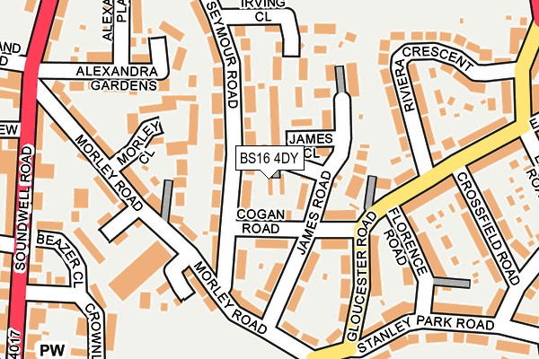
BS16 4DY is located in the Staple Hill & Mangotsfield electoral ward, within the unitary authority of South Gloucestershire and the English Parliamentary constituency of Filton and Bradley Stoke. The Sub Integrated Care Board (ICB) Location is NHS Bristol, North Somerset and South Gloucestershire ICB - 15C and the police force is Avon and Somerset. This postcode has been in use since February 2017.


GetTheData
Source: OS OpenMap – Local (Ordnance Survey)
Source: OS VectorMap District (Ordnance Survey)
Licence: Open Government Licence (requires attribution)
| Easting | 365096 |
| Northing | 175471 |
| Latitude | 51.477112 |
| Longitude | -2.503974 |
GetTheData
Source: Open Postcode Geo
Licence: Open Government Licence
| Country | England |
| Postcode District | BS16 |
➜ See where BS16 is on a map ➜ Where is Mangotsfield? | |
GetTheData
Source: Land Registry Price Paid Data
Licence: Open Government Licence
| Ward | Staple Hill & Mangotsfield |
| Constituency | Filton And Bradley Stoke |
GetTheData
Source: ONS Postcode Database
Licence: Open Government Licence
| Morley Road | Soundwell | 116m |
| Morley Road | Staple Hill | 158m |
| Gloucester Road (Stanley Park Road) | Soundwell | 210m |
| Gloucester Road (Stanley Park Road) | Soundwell | 218m |
| Portland Street | Staple Hill | 266m |
| Stapleton Road Station | 4.5km |
| Lawrence Hill Station | 4.7km |
| Bristol Parkway Station | 4.9km |
GetTheData
Source: NaPTAN
Licence: Open Government Licence
| Percentage of properties with Next Generation Access | 100.0% |
| Percentage of properties with Superfast Broadband | 100.0% |
| Percentage of properties with Ultrafast Broadband | 100.0% |
| Percentage of properties with Full Fibre Broadband | 0.0% |
Superfast Broadband is between 30Mbps and 300Mbps
Ultrafast Broadband is > 300Mbps
| Percentage of properties unable to receive 2Mbps | 0.0% |
| Percentage of properties unable to receive 5Mbps | 0.0% |
| Percentage of properties unable to receive 10Mbps | 0.0% |
| Percentage of properties unable to receive 30Mbps | 0.0% |
GetTheData
Source: Ofcom
Licence: Ofcom Terms of Use (requires attribution)
GetTheData
Source: ONS Postcode Database
Licence: Open Government Licence


➜ Get more ratings from the Food Standards Agency
GetTheData
Source: Food Standards Agency
Licence: FSA terms & conditions
| Last Collection | |||
|---|---|---|---|
| Location | Mon-Fri | Sat | Distance |
| Eastleigh Close | 17:45 | 12:30 | 292m |
| Broad Street | 17:15 | 12:00 | 439m |
| Soundwell Road | 17:45 | 12:30 | 441m |
GetTheData
Source: Dracos
Licence: Creative Commons Attribution-ShareAlike
The below table lists the International Territorial Level (ITL) codes (formerly Nomenclature of Territorial Units for Statistics (NUTS) codes) and Local Administrative Units (LAU) codes for BS16 4DY:
| ITL 1 Code | Name |
|---|---|
| TLK | South West (England) |
| ITL 2 Code | Name |
| TLK1 | Gloucestershire, Wiltshire and Bath/Bristol area |
| ITL 3 Code | Name |
| TLK12 | Bath and North East Somerset, North Somerset and South Gloucestershire |
| LAU 1 Code | Name |
| E06000025 | South Gloucestershire |
GetTheData
Source: ONS Postcode Directory
Licence: Open Government Licence
The below table lists the Census Output Area (OA), Lower Layer Super Output Area (LSOA), and Middle Layer Super Output Area (MSOA) for BS16 4DY:
| Code | Name | |
|---|---|---|
| OA | E00075667 | |
| LSOA | E01014973 | South Gloucestershire 026D |
| MSOA | E02003115 | South Gloucestershire 026 |
GetTheData
Source: ONS Postcode Directory
Licence: Open Government Licence
| BS16 4SX | Cogan Road | 45m |
| BS16 4TB | Seymour Road | 66m |
| BS16 4TQ | James Close | 72m |
| BS16 4TD | Seymour Road | 78m |
| BS16 4TA | Seymour Road | 97m |
| BS16 4SY | James Road | 99m |
| BS16 4QX | The Gardens | 105m |
| BS16 4QT | Morley Road | 107m |
| BS16 4SW | Narrow Lane | 108m |
| BS16 4SZ | James Road | 125m |
GetTheData
Source: Open Postcode Geo; Land Registry Price Paid Data
Licence: Open Government Licence