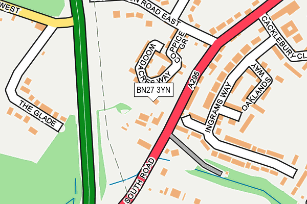
BN27 3YN is located in the Hailsham South electoral ward, within the local authority district of Wealden and the English Parliamentary constituency of Wealden. The Sub Integrated Care Board (ICB) Location is NHS Sussex ICB - 97R and the police force is Sussex. This postcode has been in use since April 2017.


GetTheData
Source: OS OpenMap – Local (Ordnance Survey)
Source: OS VectorMap District (Ordnance Survey)
Licence: Open Government Licence (requires attribution)
| Easting | 558057 |
| Northing | 108571 |
| Latitude | 50.855056 |
| Longitude | 0.244220 |
GetTheData
Source: Open Postcode Geo
Licence: Open Government Licence
| Country | England |
| Postcode District | BN27 |
➜ See where BN27 is on a map ➜ Where is Hailsham? | |
GetTheData
Source: Land Registry Price Paid Data
Licence: Open Government Licence
| Ward | Hailsham South |
| Constituency | Wealden |
GetTheData
Source: ONS Postcode Database
Licence: Open Government Licence
2024 6 SEP £380,000 |
2023 21 SEP £350,000 |
2021 18 OCT £400,000 |
14, ORCHARD LANE, HAILSHAM, BN27 3YN 2020 3 DEC £375,000 |
16, ORCHARD LANE, HAILSHAM, BN27 3YN 2020 24 JUL £335,000 |
30, ORCHARD LANE, HAILSHAM, BN27 3YN 2020 1 JUL £350,000 |
22, ORCHARD LANE, HAILSHAM, BN27 3YN 2020 7 MAY £325,000 |
10, ORCHARD LANE, HAILSHAM, BN27 3YN 2020 14 FEB £308,000 |
28, ORCHARD LANE, HAILSHAM, BN27 3YN 2019 11 DEC £325,000 |
24, ORCHARD LANE, HAILSHAM, BN27 3YN 2019 30 AUG £340,000 |
GetTheData
Source: HM Land Registry Price Paid Data
Licence: Contains HM Land Registry data © Crown copyright and database right 2025. This data is licensed under the Open Government Licence v3.0.
| Ingrams Way | Hailsham | 197m |
| Ingrams Way (South Road) | Hailsham | 260m |
| Ingrams Way (South Road) | Hailsham | 313m |
| Meadow Road | Hailsham | 334m |
| Sandbanks Way | Hailsham | 510m |
| Polegate Station | 3.8km |
GetTheData
Source: NaPTAN
Licence: Open Government Licence
| Percentage of properties with Next Generation Access | 100.0% |
| Percentage of properties with Superfast Broadband | 100.0% |
| Percentage of properties with Ultrafast Broadband | 0.0% |
| Percentage of properties with Full Fibre Broadband | 0.0% |
Superfast Broadband is between 30Mbps and 300Mbps
Ultrafast Broadband is > 300Mbps
| Median download speed | 37.1Mbps |
| Average download speed | 32.7Mbps |
| Maximum download speed | 41.61Mbps |
| Median upload speed | 9.7Mbps |
| Average upload speed | 7.7Mbps |
| Maximum upload speed | 10.00Mbps |
| Percentage of properties unable to receive 2Mbps | 0.0% |
| Percentage of properties unable to receive 5Mbps | 0.0% |
| Percentage of properties unable to receive 10Mbps | 0.0% |
| Percentage of properties unable to receive 30Mbps | 0.0% |
GetTheData
Source: Ofcom
Licence: Ofcom Terms of Use (requires attribution)
GetTheData
Source: ONS Postcode Database
Licence: Open Government Licence


➜ Get more ratings from the Food Standards Agency
GetTheData
Source: Food Standards Agency
Licence: FSA terms & conditions
| Last Collection | |||
|---|---|---|---|
| Location | Mon-Fri | Sat | Distance |
| Arlington Road East | 17:00 | 12:00 | 210m |
| Robin Post Lane | 16:00 | 08:00 | 222m |
| Ersham Road | 17:00 | 12:00 | 619m |
GetTheData
Source: Dracos
Licence: Creative Commons Attribution-ShareAlike
The below table lists the International Territorial Level (ITL) codes (formerly Nomenclature of Territorial Units for Statistics (NUTS) codes) and Local Administrative Units (LAU) codes for BN27 3YN:
| ITL 1 Code | Name |
|---|---|
| TLJ | South East (England) |
| ITL 2 Code | Name |
| TLJ2 | Surrey, East and West Sussex |
| ITL 3 Code | Name |
| TLJ22 | East Sussex CC |
| LAU 1 Code | Name |
| E07000065 | Wealden |
GetTheData
Source: ONS Postcode Directory
Licence: Open Government Licence
The below table lists the Census Output Area (OA), Lower Layer Super Output Area (LSOA), and Middle Layer Super Output Area (MSOA) for BN27 3YN:
| Code | Name | |
|---|---|---|
| OA | E00107604 | |
| LSOA | E01021180 | Wealden 016A |
| MSOA | E02004418 | Wealden 016 |
GetTheData
Source: ONS Postcode Directory
Licence: Open Government Licence
| BN27 3NU | South Road | 117m |
| BN27 3NH | Arlington Road East | 119m |
| BN27 3RB | The Glade | 167m |
| BN27 3NT | South Road | 174m |
| BN27 3NS | South Road | 176m |
| BN27 3NG | Whiffens Close | 178m |
| BN27 3RA | Robin Post Lane | 179m |
| BN27 3NP | Ingrams Way | 185m |
| BN27 3NQ | Quintin Close | 239m |
| BN27 3NF | Meadow Road | 240m |
GetTheData
Source: Open Postcode Geo; Land Registry Price Paid Data
Licence: Open Government Licence