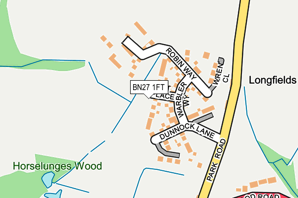
BN27 1FT is located in the Hellingly electoral ward, within the local authority district of Wealden and the English Parliamentary constituency of Wealden. The Sub Integrated Care Board (ICB) Location is NHS Sussex ICB - 97R and the police force is Sussex. This postcode has been in use since May 2017.


GetTheData
Source: OS OpenMap – Local (Ordnance Survey)
Source: OS VectorMap District (Ordnance Survey)
Licence: Open Government Licence (requires attribution)
| Easting | 558719 |
| Northing | 111510 |
| Latitude | 50.881283 |
| Longitude | 0.254892 |
GetTheData
Source: Open Postcode Geo
Licence: Open Government Licence
| Country | England |
| Postcode District | BN27 |
➜ See where BN27 is on a map ➜ Where is Hellingly? | |
GetTheData
Source: Land Registry Price Paid Data
Licence: Open Government Licence
| Ward | Hellingly |
| Constituency | Wealden |
GetTheData
Source: ONS Postcode Database
Licence: Open Government Licence
10, PIPIT PLACE, HELLINGLY, HAILSHAM, BN27 1FT 2017 25 SEP £499,995 |
8, PIPIT PLACE, HELLINGLY, HAILSHAM, BN27 1FT 2017 22 SEP £444,995 |
2, PIPIT PLACE, HELLINGLY, HAILSHAM, BN27 1FT 2017 31 AUG £329,995 |
1, PIPIT PLACE, HELLINGLY, HAILSHAM, BN27 1FT 2017 18 AUG £298,000 |
6, PIPIT PLACE, HELLINGLY, HAILSHAM, BN27 1FT 2017 30 JUN £404,995 |
4, PIPIT PLACE, HELLINGLY, HAILSHAM, BN27 1FT 2017 30 JUN £394,995 |
7, PIPIT PLACE, HELLINGLY, HAILSHAM, BN27 1FT 2017 26 JUN £444,995 |
9, PIPIT PLACE, HELLINGLY, HAILSHAM, BN27 1FT 2017 23 JUN £499,995 |
5, PIPIT PLACE, HELLINGLY, HAILSHAM, BN27 1FT 2017 20 JUN £394,995 |
3, PIPIT PLACE, HELLINGLY, HAILSHAM, BN27 1FT 2017 16 JUN £394,995 |
GetTheData
Source: HM Land Registry Price Paid Data
Licence: Contains HM Land Registry data © Crown copyright and database right 2025. This data is licensed under the Open Government Licence v3.0.
| Provenders Lodge (Upper Horsebridge Road) | Upper Horsebridge | 299m |
| Provenders Lodge (Upper Horsebridge Road) | Upper Horsebridge | 308m |
| Hawkes Farm School (Hawks Road) | Upper Horsebridge | 373m |
| Hawkes Farm School (Hawks Road) | Upper Horsebridge | 388m |
| Hawkswood Drive (Hawkswood Road) | Upper Horsebridge | 487m |
GetTheData
Source: NaPTAN
Licence: Open Government Licence
| Percentage of properties with Next Generation Access | 100.0% |
| Percentage of properties with Superfast Broadband | 100.0% |
| Percentage of properties with Ultrafast Broadband | 100.0% |
| Percentage of properties with Full Fibre Broadband | 100.0% |
Superfast Broadband is between 30Mbps and 300Mbps
Ultrafast Broadband is > 300Mbps
| Median download speed | 31.5Mbps |
| Average download speed | 30.9Mbps |
| Maximum download speed | 55.00Mbps |
| Median upload speed | 7.2Mbps |
| Average upload speed | 6.4Mbps |
| Maximum upload speed | 10.00Mbps |
| Percentage of properties unable to receive 2Mbps | 0.0% |
| Percentage of properties unable to receive 5Mbps | 0.0% |
| Percentage of properties unable to receive 10Mbps | 0.0% |
| Percentage of properties unable to receive 30Mbps | 0.0% |
GetTheData
Source: Ofcom
Licence: Ofcom Terms of Use (requires attribution)
GetTheData
Source: ONS Postcode Database
Licence: Open Government Licence


➜ Get more ratings from the Food Standards Agency
GetTheData
Source: Food Standards Agency
Licence: FSA terms & conditions
| Last Collection | |||
|---|---|---|---|
| Location | Mon-Fri | Sat | Distance |
| Hawks Road | 17:00 | 12:00 | 382m |
| Hellingly Post Office | 16:00 | 08:45 | 542m |
| Hawkswood Post Office | 16:45 | 12:00 | 573m |
GetTheData
Source: Dracos
Licence: Creative Commons Attribution-ShareAlike
The below table lists the International Territorial Level (ITL) codes (formerly Nomenclature of Territorial Units for Statistics (NUTS) codes) and Local Administrative Units (LAU) codes for BN27 1FT:
| ITL 1 Code | Name |
|---|---|
| TLJ | South East (England) |
| ITL 2 Code | Name |
| TLJ2 | Surrey, East and West Sussex |
| ITL 3 Code | Name |
| TLJ22 | East Sussex CC |
| LAU 1 Code | Name |
| E07000065 | Wealden |
GetTheData
Source: ONS Postcode Directory
Licence: Open Government Licence
The below table lists the Census Output Area (OA), Lower Layer Super Output Area (LSOA), and Middle Layer Super Output Area (MSOA) for BN27 1FT:
| Code | Name | |
|---|---|---|
| OA | E00107682 | |
| LSOA | E01021195 | Wealden 018D |
| MSOA | E02004420 | Wealden 018 |
GetTheData
Source: ONS Postcode Directory
Licence: Open Government Licence
| BN27 1PA | Longfield Cottages | 144m |
| BN27 1UZ | Union Corner | 275m |
| BN27 1NX | Upper Horsebridge Road | 309m |
| BN27 1HH | Hawkstown View | 312m |
| BN27 1UY | Hawkswood Road | 315m |
| BN27 1NA | Hawks Road | 319m |
| BN27 1PB | Park Road | 320m |
| BN27 1NY | Upper Horsebridge Road | 321m |
| BN27 1HR | Hawks Town Gardens | 340m |
| BN27 1BY | Marlow Drive | 361m |
GetTheData
Source: Open Postcode Geo; Land Registry Price Paid Data
Licence: Open Government Licence