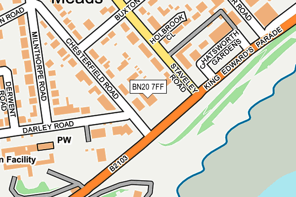
BN20 7FF is located in the Meads electoral ward, within the local authority district of Eastbourne and the English Parliamentary constituency of Eastbourne. The Sub Integrated Care Board (ICB) Location is NHS Sussex ICB - 97R and the police force is Sussex. This postcode has been in use since May 2017.


GetTheData
Source: OS OpenMap – Local (Ordnance Survey)
Source: OS VectorMap District (Ordnance Survey)
Licence: Open Government Licence (requires attribution)
| Easting | 560413 |
| Northing | 97544 |
| Latitude | 50.755325 |
| Longitude | 0.272851 |
GetTheData
Source: Open Postcode Geo
Licence: Open Government Licence
| Country | England |
| Postcode District | BN20 |
➜ See where BN20 is on a map ➜ Where is Eastbourne? | |
GetTheData
Source: Land Registry Price Paid Data
Licence: Open Government Licence
| Ward | Meads |
| Constituency | Eastbourne |
GetTheData
Source: ONS Postcode Database
Licence: Open Government Licence
APARTMENT 2, HOLYWELL COURT, 30, KING EDWARDS PARADE, EASTBOURNE, BN20 7FF 2014 25 SEP £2,250,000 |
APARTMENT 2, HOLYWELL COURT, 30, KING EDWARDS PARADE, EASTBOURNE, BN20 7FF 2009 6 NOV £800,000 |
GetTheData
Source: HM Land Registry Price Paid Data
Licence: Contains HM Land Registry data © Crown copyright and database right 2025. This data is licensed under the Open Government Licence v3.0.
| Hospital Gardens (Chesterfield Road) | Meads | 57m |
| All Saints (King Edward's Parade) | Meads | 73m |
| Bolsover Road (King Edward's Parade) | Meads | 282m |
| Chesterfield Road (Milnthorpe Road) | Meads | 288m |
| All Saints (Darley Road) | Meads | 310m |
| Eastbourne Station | 1.7km |
| Hampden Park (Sussex) Station | 4.6km |
GetTheData
Source: NaPTAN
Licence: Open Government Licence
| Percentage of properties with Next Generation Access | 100.0% |
| Percentage of properties with Superfast Broadband | 100.0% |
| Percentage of properties with Ultrafast Broadband | 0.0% |
| Percentage of properties with Full Fibre Broadband | 0.0% |
Superfast Broadband is between 30Mbps and 300Mbps
Ultrafast Broadband is > 300Mbps
| Median download speed | 30.8Mbps |
| Average download speed | 32.7Mbps |
| Maximum download speed | 46.87Mbps |
| Median upload speed | 7.1Mbps |
| Average upload speed | 6.8Mbps |
| Maximum upload speed | 8.76Mbps |
| Percentage of properties unable to receive 2Mbps | 0.0% |
| Percentage of properties unable to receive 5Mbps | 0.0% |
| Percentage of properties unable to receive 10Mbps | 0.0% |
| Percentage of properties unable to receive 30Mbps | 0.0% |
GetTheData
Source: Ofcom
Licence: Ofcom Terms of Use (requires attribution)
GetTheData
Source: ONS Postcode Database
Licence: Open Government Licence


➜ Get more ratings from the Food Standards Agency
GetTheData
Source: Food Standards Agency
Licence: FSA terms & conditions
| Last Collection | |||
|---|---|---|---|
| Location | Mon-Fri | Sat | Distance |
| Darley Road | 17:30 | 11:00 | 52m |
| Stavely Road | 17:30 | 11:00 | 128m |
| Chatsworth Gardens | 17:30 | 11:00 | 221m |
GetTheData
Source: Dracos
Licence: Creative Commons Attribution-ShareAlike
The below table lists the International Territorial Level (ITL) codes (formerly Nomenclature of Territorial Units for Statistics (NUTS) codes) and Local Administrative Units (LAU) codes for BN20 7FF:
| ITL 1 Code | Name |
|---|---|
| TLJ | South East (England) |
| ITL 2 Code | Name |
| TLJ2 | Surrey, East and West Sussex |
| ITL 3 Code | Name |
| TLJ22 | East Sussex CC |
| LAU 1 Code | Name |
| E07000061 | Eastbourne |
GetTheData
Source: ONS Postcode Directory
Licence: Open Government Licence
The below table lists the Census Output Area (OA), Lower Layer Super Output Area (LSOA), and Middle Layer Super Output Area (MSOA) for BN20 7FF:
| Code | Name | |
|---|---|---|
| OA | E00106256 | |
| LSOA | E01020934 | Eastbourne 012D |
| MSOA | E02004367 | Eastbourne 012 |
GetTheData
Source: ONS Postcode Directory
Licence: Open Government Licence
| BN20 7JY | Staveley Road | 45m |
| BN20 7NX | Chesterfield Road | 78m |
| BN20 7JZ | Staveley Road | 81m |
| BN20 7GA | Darley Road | 85m |
| BN20 7NJ | Chesterfield Gardens | 88m |
| BN20 7NU | Chesterfield Road | 92m |
| BN20 7JS | Staveley Road | 108m |
| BN20 7GB | Darley Road | 124m |
| BN20 7JX | Staveley Road | 129m |
| BN20 7PB | Darley Road | 150m |
GetTheData
Source: Open Postcode Geo; Land Registry Price Paid Data
Licence: Open Government Licence