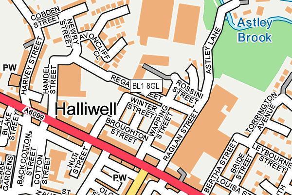
BL1 8GL is located in the Halliwell electoral ward, within the metropolitan district of Bolton and the English Parliamentary constituency of Bolton North East. The Sub Integrated Care Board (ICB) Location is NHS Greater Manchester ICB - 00T and the police force is Greater Manchester. This postcode has been in use since July 2017.


GetTheData
Source: OS OpenMap – Local (Ordnance Survey)
Source: OS VectorMap District (Ordnance Survey)
Licence: Open Government Licence (requires attribution)
| Easting | 370850 |
| Northing | 411025 |
| Latitude | 53.594997 |
| Longitude | -2.441897 |
GetTheData
Source: Open Postcode Geo
Licence: Open Government Licence
| Country | England |
| Postcode District | BL1 |
➜ See where BL1 is on a map ➜ Where is Bolton? | |
GetTheData
Source: Land Registry Price Paid Data
Licence: Open Government Licence
| Ward | Halliwell |
| Constituency | Bolton North East |
GetTheData
Source: ONS Postcode Database
Licence: Open Government Licence
| Halliwell Road/Eskrick Street (Halliwell Road) | Halliwell | 136m |
| Halliwell Road/Robin Hood Inn (Halliwell Road) | Halliwell | 152m |
| Halliwell Road/Post Office (Halliwell Road) | Halliwell | 172m |
| Halliwell Road/Rushey Fold Lane (Halliwell Road) | Halliwell | 241m |
| Halliwell Road/Horace Street (Halliwell Road) | Halliwell | 278m |
| Hall i' th' Wood Station | 1.9km |
| Bolton Station | 2.6km |
| Bromley Cross Station | 3km |
GetTheData
Source: NaPTAN
Licence: Open Government Licence
| Percentage of properties with Next Generation Access | 100.0% |
| Percentage of properties with Superfast Broadband | 100.0% |
| Percentage of properties with Ultrafast Broadband | 100.0% |
| Percentage of properties with Full Fibre Broadband | 0.0% |
Superfast Broadband is between 30Mbps and 300Mbps
Ultrafast Broadband is > 300Mbps
| Percentage of properties unable to receive 2Mbps | 0.0% |
| Percentage of properties unable to receive 5Mbps | 0.0% |
| Percentage of properties unable to receive 10Mbps | 0.0% |
| Percentage of properties unable to receive 30Mbps | 0.0% |
GetTheData
Source: Ofcom
Licence: Ofcom Terms of Use (requires attribution)
GetTheData
Source: ONS Postcode Database
Licence: Open Government Licence


➜ Get more ratings from the Food Standards Agency
GetTheData
Source: Food Standards Agency
Licence: FSA terms & conditions
| Last Collection | |||
|---|---|---|---|
| Location | Mon-Fri | Sat | Distance |
| Bolton North Delivery Office | 18:45 | 12:25 | 538m |
| Tennyson Street | 17:10 | 11:10 | 547m |
| Bolton North Delivery Office | 18:45 | 620m | |
GetTheData
Source: Dracos
Licence: Creative Commons Attribution-ShareAlike
The below table lists the International Territorial Level (ITL) codes (formerly Nomenclature of Territorial Units for Statistics (NUTS) codes) and Local Administrative Units (LAU) codes for BL1 8GL:
| ITL 1 Code | Name |
|---|---|
| TLD | North West (England) |
| ITL 2 Code | Name |
| TLD3 | Greater Manchester |
| ITL 3 Code | Name |
| TLD36 | Greater Manchester North West |
| LAU 1 Code | Name |
| E08000001 | Bolton |
GetTheData
Source: ONS Postcode Directory
Licence: Open Government Licence
The below table lists the Census Output Area (OA), Lower Layer Super Output Area (LSOA), and Middle Layer Super Output Area (MSOA) for BL1 8GL:
| Code | Name | |
|---|---|---|
| OA | E00024642 | |
| LSOA | E01004865 | Bolton 011D |
| MSOA | E02000994 | Bolton 011 |
GetTheData
Source: ONS Postcode Directory
Licence: Open Government Licence
| BL1 8AY | Duxbury Street | 47m |
| BL1 8AZ | Winter Street | 54m |
| BL1 8AR | Regan Street | 57m |
| BL1 8BA | Tennis Street | 62m |
| BL1 8AX | Broughton Street | 87m |
| BL1 8AN | Halliwell Road | 149m |
| BL1 8AP | Halliwell Road | 157m |
| BL1 8BD | Avoncliff Close | 173m |
| BL1 8DF | Halliwell Road | 174m |
| BL1 8DE | Halliwell Road | 180m |
GetTheData
Source: Open Postcode Geo; Land Registry Price Paid Data
Licence: Open Government Licence