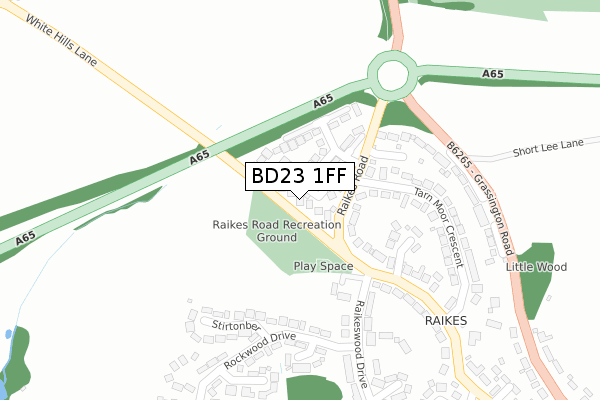
BD23 1FF is located in the Skipton North & Embsay-with-Eastby electoral ward, within the unitary authority of North Yorkshire and the English Parliamentary constituency of Skipton and Ripon. The Sub Integrated Care Board (ICB) Location is NHS West Yorkshire ICB - 36J and the police force is North Yorkshire. This postcode has been in use since October 2018.


GetTheData
Source: OS Open Zoomstack (Ordnance Survey)
Licence: Open Government Licence (requires attribution)
Attribution: Contains OS data © Crown copyright and database right 2025
Source: Open Postcode Geo
Licence: Open Government Licence (requires attribution)
Attribution: Contains OS data © Crown copyright and database right 2025; Contains Royal Mail data © Royal Mail copyright and database right 2025; Source: Office for National Statistics licensed under the Open Government Licence v.3.0
| Easting | 398179 |
| Northing | 452556 |
| Latitude | 53.969088 |
| Longitude | -2.029252 |
GetTheData
Source: Open Postcode Geo
Licence: Open Government Licence
| Country | England |
| Postcode District | BD23 |
➜ See where BD23 is on a map ➜ Where is Skipton? | |
GetTheData
Source: Land Registry Price Paid Data
Licence: Open Government Licence
| Ward | Skipton North & Embsay-with-eastby |
| Constituency | Skipton And Ripon |
GetTheData
Source: ONS Postcode Database
Licence: Open Government Licence
| Tarnmoor Crescent (Raikes Road) | Skipton | 320m |
| Tarnmoor Crescent (Raikes Road) | Skipton | 324m |
| Sod Hill (B6265) | Skipton | 332m |
| Sod Hill (B6265) | Skipton | 340m |
| Hill Rise (Raikes Road) | Skipton | 471m |
| Skipton Station | 1.2km |
| Gargrave Station | 5.1km |
GetTheData
Source: NaPTAN
Licence: Open Government Licence
| Percentage of properties with Next Generation Access | 100.0% |
| Percentage of properties with Superfast Broadband | 100.0% |
| Percentage of properties with Ultrafast Broadband | 0.0% |
| Percentage of properties with Full Fibre Broadband | 0.0% |
Superfast Broadband is between 30Mbps and 300Mbps
Ultrafast Broadband is > 300Mbps
| Median download speed | 35.9Mbps |
| Average download speed | 37.3Mbps |
| Maximum download speed | 46.27Mbps |
| Median upload speed | 9.9Mbps |
| Average upload speed | 9.5Mbps |
| Maximum upload speed | 10.15Mbps |
| Percentage of properties unable to receive 2Mbps | 0.0% |
| Percentage of properties unable to receive 5Mbps | 0.0% |
| Percentage of properties unable to receive 10Mbps | 0.0% |
| Percentage of properties unable to receive 30Mbps | 0.0% |
GetTheData
Source: Ofcom
Licence: Ofcom Terms of Use (requires attribution)
GetTheData
Source: ONS Postcode Database
Licence: Open Government Licence


➜ Get more ratings from the Food Standards Agency
GetTheData
Source: Food Standards Agency
Licence: FSA terms & conditions
| Last Collection | |||
|---|---|---|---|
| Location | Mon-Fri | Sat | Distance |
| Raikes Road | 17:30 | 12:30 | 430m |
| Rockwood Drive | 17:30 | 12:15 | 587m |
| 12 Gargrave Road | 17:30 | 12:15 | 814m |
GetTheData
Source: Dracos
Licence: Creative Commons Attribution-ShareAlike
The below table lists the International Territorial Level (ITL) codes (formerly Nomenclature of Territorial Units for Statistics (NUTS) codes) and Local Administrative Units (LAU) codes for BD23 1FF:
| ITL 1 Code | Name |
|---|---|
| TLE | Yorkshire and The Humber |
| ITL 2 Code | Name |
| TLE2 | North Yorkshire |
| ITL 3 Code | Name |
| TLE22 | North Yorkshire CC |
| LAU 1 Code | Name |
| E07000163 | Craven |
GetTheData
Source: ONS Postcode Directory
Licence: Open Government Licence
The below table lists the Census Output Area (OA), Lower Layer Super Output Area (LSOA), and Middle Layer Super Output Area (MSOA) for BD23 1FF:
| Code | Name | |
|---|---|---|
| OA | E00140382 | |
| LSOA | E01027576 | Craven 004C |
| MSOA | E02005745 | Craven 004 |
GetTheData
Source: ONS Postcode Directory
Licence: Open Government Licence
| BD23 1LU | Raikes Road | 96m |
| BD23 1LX | Ridgeway | 170m |
| BD23 1LW | White Hills Croft | 206m |
| BD23 1NH | Stirtonber | 224m |
| BD23 1LT | Tarn Moor Crescent | 243m |
| BD23 1NF | Rockwood Drive | 258m |
| BD23 1LZ | Wood Close | 280m |
| BD23 1LS | Raikes Road | 285m |
| BD23 1TZ | Woodlands Walk | 299m |
| BD23 1LY | Raikeswood Drive | 333m |
GetTheData
Source: Open Postcode Geo; Land Registry Price Paid Data
Licence: Open Government Licence