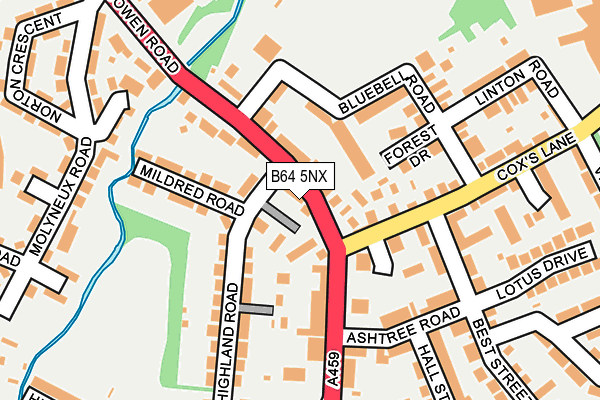
B64 5NX is located in the Rowley electoral ward, within the metropolitan district of Sandwell and the English Parliamentary constituency of Halesowen and Rowley Regis. The Sub Integrated Care Board (ICB) Location is NHS Black Country ICB - D2P2L and the police force is West Midlands. This postcode has been in use since March 2017.


GetTheData
Source: OS OpenMap – Local (Ordnance Survey)
Source: OS VectorMap District (Ordnance Survey)
Licence: Open Government Licence (requires attribution)
| Easting | 395417 |
| Northing | 286959 |
| Latitude | 52.480551 |
| Longitude | -2.068904 |
GetTheData
Source: Open Postcode Geo
Licence: Open Government Licence
| Country | England |
| Postcode District | B64 |
➜ See where B64 is on a map ➜ Where is Old Hill? | |
GetTheData
Source: Land Registry Price Paid Data
Licence: Open Government Licence
| Ward | Rowley |
| Constituency | Halesowen And Rowley Regis |
GetTheData
Source: ONS Postcode Database
Licence: Open Government Licence
| Cox's Lane (Halesowen Rd) | Brickhouse Farm | 123m |
| Cox's Lane (Halesowen Rd) | Brickhouse Farm | 138m |
| Molyneux Rd (Halesowen Rd) | Darby End | 219m |
| Old Hill Cross (Halesowen Rd) | Old Hill | 234m |
| Molyneux Rd (Halesowen Rd) | Darby End | 283m |
| Old Hill Station | 1.4km |
| Cradley Heath Station | 1.9km |
| Rowley Regis Station | 2.6km |
GetTheData
Source: NaPTAN
Licence: Open Government Licence
| Percentage of properties with Next Generation Access | 100.0% |
| Percentage of properties with Superfast Broadband | 100.0% |
| Percentage of properties with Ultrafast Broadband | 100.0% |
| Percentage of properties with Full Fibre Broadband | 0.0% |
Superfast Broadband is between 30Mbps and 300Mbps
Ultrafast Broadband is > 300Mbps
| Median download speed | 12.0Mbps |
| Average download speed | 33.7Mbps |
| Maximum download speed | 80.00Mbps |
| Median upload speed | 1.2Mbps |
| Average upload speed | 7.3Mbps |
| Maximum upload speed | 20.00Mbps |
| Percentage of properties unable to receive 2Mbps | 0.0% |
| Percentage of properties unable to receive 5Mbps | 0.0% |
| Percentage of properties unable to receive 10Mbps | 0.0% |
| Percentage of properties unable to receive 30Mbps | 0.0% |
GetTheData
Source: Ofcom
Licence: Ofcom Terms of Use (requires attribution)
GetTheData
Source: ONS Postcode Database
Licence: Open Government Licence


➜ Get more ratings from the Food Standards Agency
GetTheData
Source: Food Standards Agency
Licence: FSA terms & conditions
| Last Collection | |||
|---|---|---|---|
| Location | Mon-Fri | Sat | Distance |
| The Cross | 17:30 | 12:00 | 211m |
| Molyneux Road | 17:30 | 11:00 | 276m |
| Powke Lane / Coxs Lane | 17:30 | 12:00 | 435m |
GetTheData
Source: Dracos
Licence: Creative Commons Attribution-ShareAlike
The below table lists the International Territorial Level (ITL) codes (formerly Nomenclature of Territorial Units for Statistics (NUTS) codes) and Local Administrative Units (LAU) codes for B64 5NX:
| ITL 1 Code | Name |
|---|---|
| TLG | West Midlands (England) |
| ITL 2 Code | Name |
| TLG3 | West Midlands |
| ITL 3 Code | Name |
| TLG37 | Sandwell |
| LAU 1 Code | Name |
| E08000028 | Sandwell |
GetTheData
Source: ONS Postcode Directory
Licence: Open Government Licence
The below table lists the Census Output Area (OA), Lower Layer Super Output Area (LSOA), and Middle Layer Super Output Area (MSOA) for B64 5NX:
| Code | Name | |
|---|---|---|
| OA | E00050799 | |
| LSOA | E01010042 | Sandwell 035F |
| MSOA | E02002077 | Sandwell 035 |
GetTheData
Source: ONS Postcode Directory
Licence: Open Government Licence
| B64 5NA | Halesowen Road | 31m |
| B64 5LY | Halesowen Road | 56m |
| B64 5NN | Bluebell Road | 89m |
| B64 5NL | Halesowen Road | 95m |
| B64 5LX | Victoria Gardens | 101m |
| B64 5NT | Coxs Lane | 102m |
| B64 5LN | Beech Mews | 105m |
| B64 5LU | Halesowen Road | 109m |
| B64 5LW | Forest Drive | 112m |
| B64 5NJ | Mildred Road | 118m |
GetTheData
Source: Open Postcode Geo; Land Registry Price Paid Data
Licence: Open Government Licence