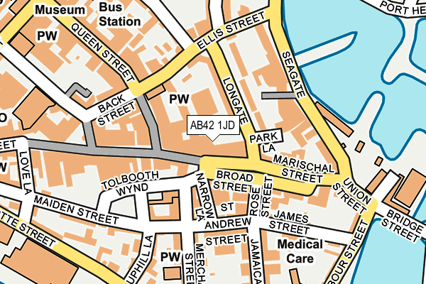
AB42 1JD is located in the Peterhead North and Rattray electoral ward, within the council area of Aberdeenshire and the Scottish Parliamentary constituency of Banff and Buchan. The Community Health Partnership is Aberdeenshire Community Health Partnership and the police force is Scotland. This postcode has been in use since June 1996.


GetTheData
Source: OS OpenMap – Local (Ordnance Survey)
Source: OS VectorMap District (Ordnance Survey)
Licence: Open Government Licence (requires attribution)
| Easting | 413457 |
| Northing | 846135 |
| Latitude | 57.505204 |
| Longitude | -1.777090 |
GetTheData
Source: Open Postcode Geo
Licence: Open Government Licence
| Country | Scotland |
| Postcode District | AB42 |
➜ See where AB42 is on a map ➜ Where is Peterhead? | |
GetTheData
Source: Land Registry Price Paid Data
Licence: Open Government Licence
| Ward | Peterhead North And Rattray |
| Constituency | Banff And Buchan |
GetTheData
Source: ONS Postcode Database
Licence: Open Government Licence
| Park Lane (Longate) | Peterhead | 66m |
| Chapel Street | Peterhead | 95m |
| Chapel Street | Peterhead | 107m |
| Back Street | Peterhead | 171m |
| Prince Street (St Peter Street) | Peterhead | 324m |
GetTheData
Source: NaPTAN
Licence: Open Government Licence
| Percentage of properties with Next Generation Access | 100.0% |
| Percentage of properties with Superfast Broadband | 100.0% |
| Percentage of properties with Ultrafast Broadband | 0.0% |
| Percentage of properties with Full Fibre Broadband | 0.0% |
Superfast Broadband is between 30Mbps and 300Mbps
Ultrafast Broadband is > 300Mbps
| Median download speed | 24.4Mbps |
| Average download speed | 41.9Mbps |
| Maximum download speed | 73.32Mbps |
| Median upload speed | 1.3Mbps |
| Average upload speed | 8.1Mbps |
| Maximum upload speed | 19.21Mbps |
| Percentage of properties unable to receive 2Mbps | 0.0% |
| Percentage of properties unable to receive 5Mbps | 0.0% |
| Percentage of properties unable to receive 10Mbps | 0.0% |
| Percentage of properties unable to receive 30Mbps | 0.0% |
GetTheData
Source: Ofcom
Licence: Ofcom Terms of Use (requires attribution)
Estimated total energy consumption in AB42 1JD by fuel type, 2015.
| Consumption (kWh) | 49,909 |
|---|---|
| Meter count | 24 |
| Mean (kWh/meter) | 2,080 |
| Median (kWh/meter) | 1,664 |
GetTheData
Source: Postcode level gas estimates: 2015 (experimental)
Source: Postcode level electricity estimates: 2015 (experimental)
Licence: Open Government Licence
GetTheData
Source: ONS Postcode Database
Licence: Open Government Licence


➜ Get more ratings from the Food Standards Agency
GetTheData
Source: Food Standards Agency
Licence: FSA terms & conditions
| Last Collection | |||
|---|---|---|---|
| Location | Mon-Fri | Sat | Distance |
| Broad Street, Peterhead | 17:00 | 12:00 | 50m |
| Longate, Peterhead | 17:00 | 12:00 | 170m |
| Peterhead Post Office | 17:30 | 12:30 | 222m |
GetTheData
Source: Dracos
Licence: Creative Commons Attribution-ShareAlike
The below table lists the International Territorial Level (ITL) codes (formerly Nomenclature of Territorial Units for Statistics (NUTS) codes) and Local Administrative Units (LAU) codes for AB42 1JD:
| ITL 1 Code | Name |
|---|---|
| TLM | Scotland |
| ITL 2 Code | Name |
| TLM5 | North Eastern Scotland |
| ITL 3 Code | Name |
| TLM50 | Aberdeen City and Aberdeenshire |
| LAU 1 Code | Name |
| S30000027 | Aberdeenshire |
GetTheData
Source: ONS Postcode Directory
Licence: Open Government Licence
The below table lists the Census Output Area (OA), Lower Layer Super Output Area (LSOA), and Middle Layer Super Output Area (MSOA) for AB42 1JD:
| Code | Name | |
|---|---|---|
| OA | S00091963 | |
| LSOA | S01007086 | Peterhead Harbour - 06 |
| MSOA | S02001336 | Peterhead Harbour |
GetTheData
Source: ONS Postcode Directory
Licence: Open Government Licence