Honeybourne Harriers Sports Field
Honeybourne Harriers Sports Field is located in Honeybourne, Evesham (WR11), and offers Grass Pitches.
| Address | Bretforton Road, Honeybourne, Evesham, WR11 7PE |
| Car Park | Yes |
| Car Park Capacity | 75 |
| Management Type | Community Organisation |
| Management Group | Others |
| Owner Type | Local Authority |
| Owner Group | Local Authority |
| Education Phase | Not applicable |
Facilities
| Accessibility | Sports Club / Community Association |
| Management Type | Community Organisation |
| Changing Rooms | Yes |
| Date Record Created | 23rd Oct 2018 |
| Date Record Checked | 11th Sep 2023 |
| Opening Times | Dawn To Dusk |
Facility specifics
Disabled access
| Disabled Access | Yes |
| Disabled Parking | Yes |
| Finding/Reaching Entrance | Yes |
| Reception Area | Yes |
| Doorways | Yes |
| Disabled Changing Facilities | Yes |
| Activity Areas | Yes |
| Disabled Toilets | Yes |
| Social Areas | Yes |
| Spectator Areas | Yes |
| Emergency Exits | Yes |
| Accessibility | Sports Club / Community Association |
| Management Type | Community Organisation |
| Changing Rooms | Yes |
| Date Record Created | 10th Jan 2020 |
| Date Record Checked | 11th Sep 2023 |
| Opening Times | Dawn To Dusk |
Facility specifics
Disabled access
| Disabled Access | Yes |
| Disabled Parking | Yes |
| Finding/Reaching Entrance | Yes |
| Reception Area | Yes |
| Doorways | Yes |
| Disabled Changing Facilities | Yes |
| Activity Areas | Yes |
| Disabled Toilets | Yes |
| Social Areas | Yes |
| Spectator Areas | Yes |
| Emergency Exits | Yes |
| Accessibility | Sports Club / Community Association |
| Management Type | Community Organisation |
| Changing Rooms | Yes |
| Date Record Created | 3rd Feb 2021 |
| Date Record Checked | 11th Sep 2023 |
| Opening Times | Dawn To Dusk |
Facility specifics
Disabled access
| Disabled Access | Yes |
| Disabled Parking | Yes |
| Finding/Reaching Entrance | Yes |
| Reception Area | Yes |
| Doorways | Yes |
| Disabled Changing Facilities | Yes |
| Activity Areas | Yes |
| Disabled Toilets | Yes |
| Social Areas | Yes |
| Spectator Areas | Yes |
| Emergency Exits | Yes |
| Accessibility | Sports Club / Community Association |
| Management Type | Community Organisation |
| Changing Rooms | Yes |
| Date Record Created | 8th Mar 2021 |
| Date Record Checked | 11th Sep 2023 |
| Opening Times | Dawn To Dusk |
Facility specifics
Disabled access
| Disabled Access | Yes |
| Disabled Parking | Yes |
| Finding/Reaching Entrance | Yes |
| Reception Area | Yes |
| Doorways | Yes |
| Disabled Changing Facilities | Yes |
| Activity Areas | Yes |
| Disabled Toilets | Yes |
| Social Areas | Yes |
| Spectator Areas | Yes |
| Emergency Exits | Yes |
Contact
Disabled access
Disabled access for Honeybourne Harriers Sports Field
| Disabled Access | Yes |
| Disabled Parking | Yes |
| Finding/Reaching Entrance | Yes |
| Reception Area | Yes |
| Doorways | Yes |
| Disabled Changing Facilities | Yes |
| Activity Areas | Yes |
| Disabled Toilets | Yes |
| Social Areas | Yes |
| Spectator Areas | Yes |
| Emergency Exits | Yes |
Where is Honeybourne Harriers Sports Field?
| Sub Building Name | |
| Building Name | |
| Building Number | 0 |
| Dependent Thoroughfare | |
| Thoroughfare Name | BRETFORTON ROAD |
| Double Dependent Locality | |
| Dependent Locality | HONEYBOURNE |
| PostTown | EVESHAM |
| Postcode | WR11 7PE |
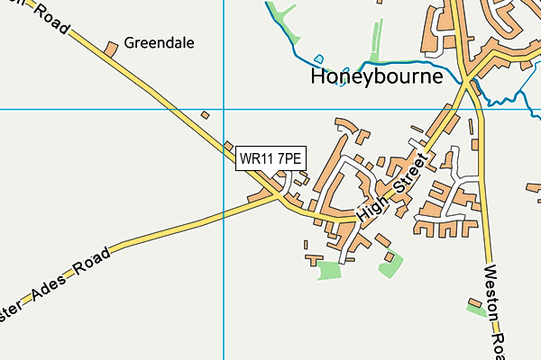
Honeybourne Harriers Sports Field on a map

Honeybourne Harriers Sports Field geodata
| Easting | 411012.28 |
| Northing | 243805.65 |
| Latitude | 52.092489 |
| Longitude | -1.840676 |
| Local Authority Name | Wychavon |
| Local Authority Code | E07000238 |
| Parliamentary Constituency Name | Mid Worcestershire |
| Parliamentary Constituency Code | E14000818 |
| Region Name | West Midlands |
| Region Code | E15000005 |
| Ward Name | Honeybourne and Pebworth |
| Ward Code | E05007916 |
| Output Area Code | E00165200 |
About this data
This data is open data sourced from Active Places Power and licenced under the Active Places Open Data Licence.
| toid | osgb1000021202935 |
| Created On | 23rd Oct 2018 |
| Audited On | 11th Sep 2023 |
| Checked On | 11th Sep 2023 |
