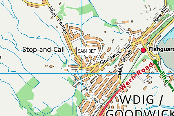
Ysgol Gynradd Sirol Wdig is located in Wdig, Sir Benfro and falls under the local authority of Pembrokeshire. The type of establishment is welsh establishment.
| Address | Ysgol Gynradd Sirol Wdig Hill Street Wdig Sir Benfro SA64 0ET |
GetTheData
Source: Get Information About Schools
Licence: Open Government Licence
| Phase of Education | Not applicable |
| Type of Establishment | Welsh establishment |
| Boarders | Not applicable |
| Official Sixth Form | Not applicable |
| Gender | Not applicable |
| Diocese | Not applicable |
| Special Classes | Not applicable |
GetTheData
Source: Get Information About Schools
Licence: Open Government Licence
| Street Address | Hill Street |
| Locality | Wdig |
| Town | Sir Benfro |
| Postcode | SA64 0ET |
| ➜ More SA64 0ET open data | |
GetTheData
Source: Get Information About Schools
Licence: Open Government Licence

GetTheData
Source: OS VectorMap District (Ordnance Survey)
Licence: Open Government Licence (requires attribution)
| Ofsted Special Measures | Not applicable |
GetTheData
Source: Get Information About Schools
Licence: Open Government Licence
| Establishment Name | Ysgol Gynradd Sirol Wdig |
| Establishment Number | 2212 |
| Unique Reference Number | 400652 |
| Local Authority | Pembrokeshire |
| Local Authority Code | 668 |
| Previous Local Authority Code | 999 |
| Government Statistical Service Local Authority Code | W06000009 |
| Government Office Region | Wales (pseudo) |
| District | Pembrokeshire |
| District Code | W06000009 |
| Ward | Goodwick |
| Parliamentary Constituency | Preseli Pembrokeshire |
| Urban/Rural Description | (England/Wales) Rural town and fringe in a sparse setting |
| Middle Super Output Area | Pembrokeshire 002 |
| Lower Super Output Area | Pembrokeshire 002D |
GetTheData
Source: Get Information About Schools
Licence: Open Government Licence
| Establishment Status | Open |
| Last Changed Date | 13th June 2022 |
| Reason Establishment Opened | Not applicable |
| Reason Establishment Closed | Not applicable |
GetTheData
Source: Get Information About Schools
Licence: Open Government Licence
| Teenage Mothers | Not applicable |
| Child Care Facilities | Not applicable |
| Special Educational Needs (SEN) Provision in Primary Care Unit | Not applicable |
| Pupil Referral Unit (PRU) Provides for Educational and Behavioural Difficulties (EBD) | Not applicable |
| Pupil Referral Unit (PRU) Offers Tuition by Another Provider | Not applicable |
GetTheData
Source: Get Information About Schools
Licence: Open Government Licence
| Section 41 Approved | Not approved |
GetTheData
Source: Get Information About Schools
Licence: Open Government Licence
| Trust flag | Not applicable |
| School Sponsor flag | Not applicable |
GetTheData
Source: Get Information About Schools
Licence: Open Government Licence
| Federation flag | Not applicable |
GetTheData
Source: Get Information About Schools
Licence: Open Government Licence
| Further Education Type | Not applicable |
GetTheData
Source: Get Information About Schools
Licence: Open Government Licence
| Easting | 194047 |
| Northing | 238130 |
| Latitude | 52.00331 |
| Longitude | -5.00189 |
GetTheData
Source: Get Information About Schools
Licence: Open Government Licence
| School | Phase of Education | Distance |
|---|---|---|
| Ysgol Bro Gwaun Heol Dyfed, Fishguard, Pembrokeshire, SA65 9DT | Not applicable | 1.2km |
| Holy Name V.R.C. School Vergam Tce, Fishguard, Pembrokeshire, SA65 9DF | Not applicable | 1.5km |
| Ysgol Glannau Gwaun Clive Road, Fishguard, SA65 9DB | Not applicable | 1.7km |
| Ysgol Ger y Llan V.C. School St David's Road, Letterson, Haverford West, Pembrokeshire, SA62 5SL | Not applicable | 8.5km |
| Ysgol Llanychllwydog Pontfaen, Fishguard, Pembrokeshire, SA65 9SE | Not applicable | 9.9km |
| Puncheston CP Puncheston, Haverfordwest, Pembrokeshire, SA62 5RL | Not applicable | 10.6km |
GetTheData
Source: Get Information About Schools
Licence: Open Government Licence