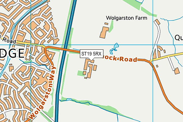
Wolgarston High School is located in Penkridge, Stafford and falls under the local authority of Staffordshire. This mixed-sex secondary school has 813 pupils, with a capacity of 860, aged from thirteen up to eighteen, and the type of establishment is academy converter. The most recend Ofsted inspection was 5th May 2022 resulting in an good rating.
| Address | Wolgarston High School Cannock Road Penkridge Stafford Staffordshire ST19 5RX |
| Website | http://www.wolgarston.staffs.sch.uk |
| Headteacher | Miss Joanne Fairclough |
GetTheData
Source: Get Information About Schools
Licence: Open Government Licence
| Phase of Education | Secondary |
| Type of Establishment | Academy converter |
| Admissions Policy | Non-selective |
| Statutory Low Age | 13 |
| Statutory High Age | 18 |
| Boarders | No boarders |
| Official Sixth Form | Has a sixth form |
| Gender | Mixed |
| Religious Character | Does not apply |
| Diocese | Not applicable |
| Special Classes | No Special Classes |
GetTheData
Source: Get Information About Schools
Licence: Open Government Licence
| Census Date | 19th January 2023 | |
| School Capacity | 860 | |
| Number of Pupils | 813 | 95% capacity |
| Number of Boys | 418 | 51% |
| Number of Girls | 395 | 49% |
| Free School Meals (%) | 11.30% |
GetTheData
Source: Get Information About Schools
Licence: Open Government Licence
| Street Address | Cannock Road |
| Locality | Penkridge |
| Town | Stafford |
| County | Staffordshire |
| Postcode | ST19 5RX |
| ➜ More ST19 5RX open data | |
GetTheData
Source: Get Information About Schools
Licence: Open Government Licence

GetTheData
Source: OS VectorMap District (Ordnance Survey)
Licence: Open Government Licence (requires attribution)
| Ofsted Last Inspection | 5th May 2022 |
| Ofsted Rating | Good |
| Ofsted Special Measures | Not applicable |
GetTheData
Source: Get Information About Schools
Licence: Open Government Licence
| Establishment Name | Wolgarston High School |
| Establishment Number | 4100 |
| Unique Reference Number | 145381 |
| Local Authority | Staffordshire |
| Local Authority Code | 860 |
| Previous Local Authority | Pre LGR (1997) Staffordshire |
| Previous Local Authority Code | 934 |
| Government Statistical Service Local Authority Code | E10000028 |
| Government Office Region | West Midlands |
| District | South Staffordshire |
| District Code | E07000196 |
| Ward | Penkridge North & Acton Trussell |
| Parliamentary Constituency | Stafford |
| Urban/Rural Description | (England/Wales) Rural hamlet and isolated dwellings |
| Middle Super Output Area | South Staffordshire 001 |
| Lower Super Output Area | South Staffordshire 001A |
GetTheData
Source: Get Information About Schools
Licence: Open Government Licence
| Establishment Status | Open |
| Last Changed Date | 23rd November 2023 |
| Reason Establishment Opened | Academy Converter |
| Open Date | 1st April 2018 |
GetTheData
Source: Get Information About Schools
Licence: Open Government Licence
| Teenage Mothers | Not applicable |
| Child Care Facilities | Not applicable |
| Special Educational Needs (SEN) Provision in Primary Care Unit | Not applicable |
| Pupil Referral Unit (PRU) Provides for Educational and Behavioural Difficulties (EBD) | Not applicable |
| Pupil Referral Unit (PRU) Offers Tuition by Another Provider | Not applicable |
GetTheData
Source: Get Information About Schools
Licence: Open Government Licence
| Section 41 Approved | Not applicable |
GetTheData
Source: Get Information About Schools
Licence: Open Government Licence
| Trust flag | Supported by a multi-academy trust |
| Trust | PENK VALLEY ACADEMY TRUST |
| School Sponsor flag | - |
GetTheData
Source: Get Information About Schools
Licence: Open Government Licence
| Federation flag | Not applicable |
GetTheData
Source: Get Information About Schools
Licence: Open Government Licence
| UK Provider Reference Number | 10066653 |
| Further Education Type | Not applicable |
GetTheData
Source: Get Information About Schools
Licence: Open Government Licence
| Easting | 393453 |
| Northing | 313836 |
| Latitude | 52.72213 |
| Longitude | -2.09837 |
GetTheData
Source: Get Information About Schools
Licence: Open Government Licence
| School | Phase of Education | Distance |
|---|---|---|
| Princefield First School Saxon Road, Penkridge, Stafford, ST19 5EP | Primary | 619m |
| Penkridge Middle School Marsh Lane, Penkridge, Stafford, ST19 5BW | Middle deemed secondary | 818m |
| St Michael's CofE (A) First School Market Place, Penkridge, Stafford, ST19 5DJ | Primary | 998m |
| Marshbrook First School Teddesley Road, Penkridge, Stafford, ST19 5BA | Primary | 1.1km |
| The Rural Enterprise Academy Rodbaston Drive, Penkridge, ST19 5PH | Secondary | 2.5km |
| South Staffordshire College Rodbaston Drive, Penkridge, Stafford, ST19 5PH | 16 plus | 2.5km |
| Longridge School Levedale Road, Penkridge, Staffordshire, ST18 9AL | Not applicable | 3.3km |
| Peak Education The Old School House, Watling Street, Gailey, Cannock, ST19 5PR | Not applicable | 3.9km |
| Littleton Green Community School Colliers Way, Huntington, Cannock, WS12 4UD | Primary | 3.9km |
| St Leonard's CofE First School School Lane, Dunston, Stafford, ST18 9AG | Primary | 4.2km |
GetTheData
Source: Get Information About Schools
Licence: Open Government Licence