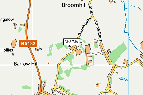
iMap Centre is located in Barnhouse Lane, Chester and falls under the local authority of Cheshire West and Chester. This mixed-sex school has 17 pupils, with a capacity of 20, aged from seven up to nineteen, and the type of establishment is other independent special school. The most recend Ofsted inspection was 27th June 2019 resulting in an good rating.
| Address | iMap Centre Unit 4a Barrowmore Estates Barnhouse Lane Great Barrow Chester Cheshire CH3 7JA |
| Website | http://www.imapcentre.co.uk |
| Headteacher | Mrs Christine Merrick |
GetTheData
Source: Get Information About Schools
Licence: Open Government Licence
| Phase of Education | Not applicable |
| Type of Establishment | Other independent special school |
| Admissions Policy | Selective |
| Statutory Low Age | 7 |
| Statutory High Age | 19 |
| Boarders | No boarders |
| Boarding Establishment | Does not have boarders |
| Official Sixth Form | Has a sixth form |
| Gender | Mixed |
| Religious Character | None |
| Diocese | Not applicable |
| Special Classes | Has Special Classes |
GetTheData
Source: Get Information About Schools
Licence: Open Government Licence
| Census Date | 20th January 2022 | |
| School Capacity | 20 | |
| Number of Pupils | 17 | 85% capacity |
| Number of Boys | 12 | 71% |
| Number of Girls | 5 | 29% |
| Free School Meals (%) | 0.0% |
GetTheData
Source: Get Information About Schools
Licence: Open Government Licence
| Street Address | Unit 4a Barrowmore Estates |
| Locality | Barnhouse Lane |
| Address 3 | Great Barrow |
| Town | Chester |
| County | Cheshire |
| Postcode | CH3 7JA |
| ➜ More CH3 7JA open data | |
GetTheData
Source: Get Information About Schools
Licence: Open Government Licence

GetTheData
Source: OS VectorMap District (Ordnance Survey)
Licence: Open Government Licence (requires attribution)
| Ofsted Last Inspection | 27th June 2019 |
| Ofsted Rating | Good |
| Ofsted Special Measures | Not applicable |
GetTheData
Source: Get Information About Schools
Licence: Open Government Licence
| Establishment Name | iMap Centre |
| Establishment Number | 6028 |
| Unique Reference Number | 131792 |
| Local Authority | Cheshire West and Chester |
| Local Authority Code | 896 |
| Previous Local Authority | Pre LGR (2009) Cheshire |
| Previous Local Authority Code | 875 |
| Government Statistical Service Local Authority Code | E06000050 |
| Government Office Region | North West |
| District | Cheshire West and Chester |
| District Code | E06000050 |
| Ward | Gowy Rural |
| Parliamentary Constituency | Eddisbury |
| Urban/Rural Description | (England/Wales) Rural village |
| Middle Super Output Area | Cheshire West and Chester 022 |
| Lower Super Output Area | Cheshire West and Chester 022A |
GetTheData
Source: Get Information About Schools
Licence: Open Government Licence
| Establishment Status | Open |
| Last Changed Date | 27th September 2023 |
| Reason Establishment Opened | Not applicable |
| Open Date | 24th March 1999 |
| Reason Establishment Closed | Not applicable |
GetTheData
Source: Get Information About Schools
Licence: Open Government Licence
| Teenage Mothers | Not applicable |
| Child Care Facilities | Not applicable |
| Special Educational Needs (SEN) Provision in Primary Care Unit | Not applicable |
| Pupil Referral Unit (PRU) Provides for Educational and Behavioural Difficulties (EBD) | Not applicable |
| Pupil Referral Unit (PRU) Offers Tuition by Another Provider | Not applicable |
GetTheData
Source: Get Information About Schools
Licence: Open Government Licence
| Section 41 Approved | Approved |
| Special Educational Needs (SEN) Priority 1 | ASD - Autistic Spectrum Disorder |
GetTheData
Source: Get Information About Schools
Licence: Open Government Licence
| Trust flag | Not applicable |
| School Sponsor flag | Not applicable |
GetTheData
Source: Get Information About Schools
Licence: Open Government Licence
| Federation flag | Not applicable |
GetTheData
Source: Get Information About Schools
Licence: Open Government Licence
| UK Provider Reference Number | 10018047 |
| Further Education Type | Not applicable |
GetTheData
Source: Get Information About Schools
Licence: Open Government Licence
| Easting | 347411 |
| Northing | 369179 |
| Latitude | 53.21705 |
| Longitude | -2.78901 |
GetTheData
Source: Get Information About Schools
Licence: Open Government Licence
| School | Phase of Education | Distance |
|---|---|---|
| Barrow CofE Primary School Barrow, School Lane, Great Barrow, Chester, CH3 7HW | Primary | 789m |
| Guilden Sutton CofE Primary School Arrowcroft Road, Guilden Sutton, Chester, CH3 7ES | Primary | 3km |
| Mickle Trafford Village School School Lane, Mickle Trafford, Chester, CH2 4EF | Primary | 3.1km |
| Tarvin Primary School Heath Drive, Tarvin, Chester, CH3 8LS | Primary | 3.1km |
| Ashton Hayes Primary School Church Road, Ashton Hayes, Chester, CH3 8AB | Primary | 3.2km |
| The Hammond Mannings Lane, Chester, CH2 4ES | Not applicable | 4.5km |
| Christleton High School Village Road, Christleton, Chester, CH3 7AD | Secondary | 4.8km |
| Oldfield Primary School Green Lane, Vicars Cross, Chester, CH3 5LB | Primary | 4.8km |
| Christleton Primary School Quarry Lane, Christleton, Chester, CH3 7AY | Primary | 5km |
| Horn's Mill Primary School Denbigh Close, Helsby, Frodsham, WA6 0ED | Primary | 5.1km |
GetTheData
Source: Get Information About Schools
Licence: Open Government Licence