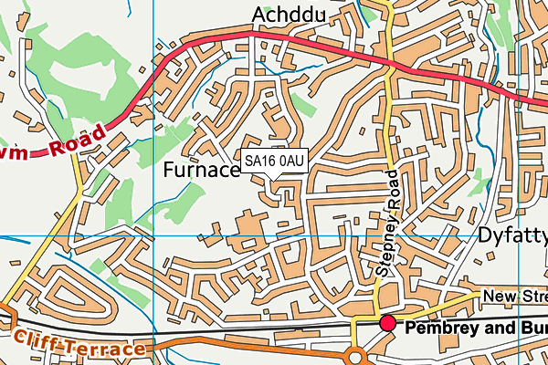
Burry Port Community Primary School is located in Burry Port and falls under the local authority of Carmarthenshire. The type of establishment is welsh establishment.
| Address | Burry Port Community Primary School Elkington Park Burry Port SA16 0AU |
GetTheData
Source: Get Information About Schools
Licence: Open Government Licence
| Phase of Education | Not applicable |
| Type of Establishment | Welsh establishment |
| Official Sixth Form | Not applicable |
| Diocese | Not applicable |
| Special Classes | Not applicable |
GetTheData
Source: Get Information About Schools
Licence: Open Government Licence
| Street Address | Elkington Park |
| Town | Burry Port |
| Postcode | SA16 0AU |
| ➜ More SA16 0AU open data | |
GetTheData
Source: Get Information About Schools
Licence: Open Government Licence

GetTheData
Source: OS VectorMap District (Ordnance Survey)
Licence: Open Government Licence (requires attribution)
| Ofsted Special Measures | Not applicable |
GetTheData
Source: Get Information About Schools
Licence: Open Government Licence
| Establishment Name | Burry Port Community Primary School |
| Establishment Number | 2394 |
| Unique Reference Number | 402326 |
| Local Authority | Carmarthenshire |
| Local Authority Code | 669 |
| Previous Local Authority Code | 999 |
| Government Statistical Service Local Authority Code | W06000010 |
| Government Office Region | Wales (pseudo) |
| District | Carmarthenshire |
| District Code | W06000010 |
| Ward | Pembrey |
| Parliamentary Constituency | Llanelli |
| Urban/Rural Description | (England/Wales) Rural town and fringe |
| Middle Super Output Area | Carmarthenshire 021 |
| Lower Super Output Area | Carmarthenshire 021D |
GetTheData
Source: Get Information About Schools
Licence: Open Government Licence
| Establishment Status | Open |
| Last Changed Date | 13th June 2022 |
| Reason Establishment Opened | New Provision |
| Open Date | 1st September 2013 |
GetTheData
Source: Get Information About Schools
Licence: Open Government Licence
| Teenage Mothers | Not applicable |
| Special Educational Needs (SEN) Provision in Primary Care Unit | Not applicable |
| Pupil Referral Unit (PRU) Provides for Educational and Behavioural Difficulties (EBD) | Not applicable |
GetTheData
Source: Get Information About Schools
Licence: Open Government Licence
| Section 41 Approved | Not approved |
GetTheData
Source: Get Information About Schools
Licence: Open Government Licence
| Trust flag | Not applicable |
| School Sponsor flag | Not applicable |
GetTheData
Source: Get Information About Schools
Licence: Open Government Licence
| Federation flag | Not applicable |
GetTheData
Source: Get Information About Schools
Licence: Open Government Licence
| Further Education Type | Not applicable |
GetTheData
Source: Get Information About Schools
Licence: Open Government Licence
| Easting | 244250 |
| Northing | 201214 |
| Latitude | 51.68802 |
| Longitude | -4.25458 |
GetTheData
Source: Get Information About Schools
Licence: Open Government Licence
| School | Phase of Education | Distance |
|---|---|---|
| Ysgol Glan-Y-Mor School Heol Elfed, Burry Port, Carmarthenshire, SA16 0AL | Not applicable | 220m |
| Parc y Tywyn Heol Elfed, Burry Port, Carmarthenshire, SA16 0AL | Not applicable | 258m |
| Pembrey C.P. School Ashburnham Road, Pembrey, Carmarthenshire, SA16 0TP | Not applicable | 1.4km |
| Trimsaran Community School Heol Llanelli, Trimsaran, Kidwelly, Carmarthenshire, SA17 4AG | Not applicable | 3.4km |
| Pwll C.P. Mixed School School Road, Pwll, Llanelli, SA15 4AL | Not applicable | 3.4km |
| Ysgol Gyfun Y Strade Heol Sandy, Llanelli, Carmarthenshire, SA15 4DL | Not applicable | 5km |
| Ysgol Gymraeg Ffwrnes Rhodfa Denham, Llanelli, Carmarthenshire, SA15 4DD | Not applicable | 5.7km |
| Carway C.P. School Carway, Kidwelly, Carmarthenshire, SA17 4HE | Not applicable | 5.7km |
| Pentip V.A. C.I.W. Primary School Pembrey Road, Llanelli, SA15 3BL | Not applicable | 6.1km |
| Ysgol Gynradd Pum Heol Heol Hen, Llanelli, Sir Gaerfyrddin, SA15 5EZ | Not applicable | 6.3km |
GetTheData
Source: Get Information About Schools
Licence: Open Government Licence