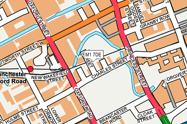
M1 7DE is located in the Deansgate electoral ward, within the metropolitan district of Manchester and the English Parliamentary constituency of Manchester Central. The Sub Integrated Care Board (ICB) Location is NHS Greater Manchester ICB - 14L and the police force is Greater Manchester. This postcode has been in use since January 1980.


GetTheData
Source: OS OpenMap – Local (Ordnance Survey)
Source: OS VectorMap District (Ordnance Survey)
Licence: Open Government Licence (requires attribution)
| Easting | 384229 |
| Northing | 397505 |
| Latitude | 53.474036 |
| Longitude | -2.239073 |
GetTheData
Source: Open Postcode Geo
Licence: Open Government Licence
| Country | England |
| Postcode District | M1 |
| ➜ M1 open data dashboard ➜ See where M1 is on a map ➜ Where is Manchester? | |
GetTheData
Source: Land Registry Price Paid Data
Licence: Open Government Licence
Elevation or altitude of M1 7DE as distance above sea level:
| Metres | Feet | |
|---|---|---|
| Elevation | 30m | 98ft |
Elevation is measured from the approximate centre of the postcode, to the nearest point on an OS contour line from OS Terrain 50, which has contour spacing of ten vertical metres.
➜ How high above sea level am I? Find the elevation of your current position using your device's GPS.
GetTheData
Source: Open Postcode Elevation
Licence: Open Government Licence
| Ward | Deansgate |
| Constituency | Manchester Central |
GetTheData
Source: ONS Postcode Database
Licence: Open Government Licence
| May 2022 | Other theft | On or near Charles Street | 102m |
| May 2022 | Violence and sexual offences | On or near Portland Street | 449m |
| ➜ Get more crime data in our Crime section | |||
GetTheData
Source: data.police.uk
Licence: Open Government Licence
| Charles St/Princess St (Charles St) | Manchester City Centre | 53m |
| Charles St/Oxford Rd (Charles St) | Manchester City Centre | 58m |
| Oxford Rd/Oxford Rd Stn (Oxford Rd) | Manchester City Centre | 90m |
| Oxford Rd/Oxford Rd Stn (Oxford Rd) | Manchester City Centre | 98m |
| Oxford Rd/Hulme St (Oxford Rd) | Manchester City Centre | 118m |
| St Peters Square (Manchester Metrolink) (Peter Street) | Manchester City Centre | 535m |
| Piccadilly (Manchester Metrolink) (London Road) | Manchester City Centre | 613m |
| Piccadilly Gardens (Manchester Metrolink) (Portland Street) | Piccadilly Gardens | 690m |
| Deansgate-castlefield (Manchester Metrolink) (Whitworth Street West) | Manchester City Centre | 816m |
| Market Street (Manchester Metrolink) (Market Street) | Manchester City Centre | 878m |
| Manchester Oxford Road Station | 0.2km |
| Manchester Piccadilly Station | 0.7km |
| Deansgate Station | 0.8km |
GetTheData
Source: NaPTAN
Licence: Open Government Licence
GetTheData
Source: ONS Postcode Database
Licence: Open Government Licence


➜ Get more ratings from the Food Standards Agency
GetTheData
Source: Food Standards Agency
Licence: FSA terms & conditions
| Last Collection | |||
|---|---|---|---|
| Location | Mon-Fri | Sat | Distance |
| Hulme Street/Oxford Street | 19:00 | 12:00 | 114m |
| Princess Street P.o. | 19:00 | 12:00 | 132m |
| Oxford Road Station | 19:00 | 12:00 | 157m |
GetTheData
Source: Dracos
Licence: Creative Commons Attribution-ShareAlike
| Facility | Distance |
|---|---|
| Jd Gyms (Manchester) Whitworth Street, Manchester Health and Fitness Gym | 149m |
| Bannatyne Health Club (Manchester Whitworth St) Whitworth Street, Manchester Swimming Pool, Health and Fitness Gym, Studio | 298m |
| Bannatyne Health Club (Manchester Chepstow Street) Chepstow Street, Manchester Health and Fitness Gym, Swimming Pool, Studio | 323m |
GetTheData
Source: Active Places
Licence: Open Government Licence
| School | Phase of Education | Distance |
|---|---|---|
| The Manchester Metropolitan University All Saints Building, Oxford Road, Manchester, M15 6BH | Not applicable | 374m |
| Royal Northern College of Music 124 Oxford Road, Manchester, M13 9RD | Not applicable | 625m |
| St Philip's Church of England Primary School Loxford Street, Hulme, Manchester, M15 6BT | Primary | 703m |
GetTheData
Source: Edubase
Licence: Open Government Licence
| Risk of M1 7DE flooding from rivers and sea | High |
| ➜ M1 7DE flood map | |
GetTheData
Source: Open Flood Risk by Postcode
Licence: Open Government Licence
The below table lists the International Territorial Level (ITL) codes (formerly Nomenclature of Territorial Units for Statistics (NUTS) codes) and Local Administrative Units (LAU) codes for M1 7DE:
| ITL 1 Code | Name |
|---|---|
| TLD | North West (England) |
| ITL 2 Code | Name |
| TLD3 | Greater Manchester |
| ITL 3 Code | Name |
| TLD33 | Manchester |
| LAU 1 Code | Name |
| E08000003 | Manchester |
GetTheData
Source: ONS Postcode Directory
Licence: Open Government Licence
The below table lists the Census Output Area (OA), Lower Layer Super Output Area (LSOA), and Middle Layer Super Output Area (MSOA) for M1 7DE:
| Code | Name | |
|---|---|---|
| OA | E00175843 | |
| LSOA | E01033662 | Manchester 057C |
| MSOA | E02006914 | Manchester 057 |
GetTheData
Source: ONS Postcode Directory
Licence: Open Government Licence
| M1 7BD | Charles Street | 20m |
| M1 6EY | Oxford Road | 64m |
| M1 6NG | Princess Street | 102m |
| M1 6BD | Princess Street | 133m |
| M1 6BE | Princess Street | 133m |
| M1 6LQ | Whitworth Street | 136m |
| M1 6NF | Princess Street | 136m |
| M1 6LT | Whitworth Street | 147m |
| M1 7AF | Princess Street | 150m |
| M1 7EP | Princess Street | 175m |
GetTheData
Source: Open Postcode Geo; Land Registry Price Paid Data
Licence: Open Government Licence