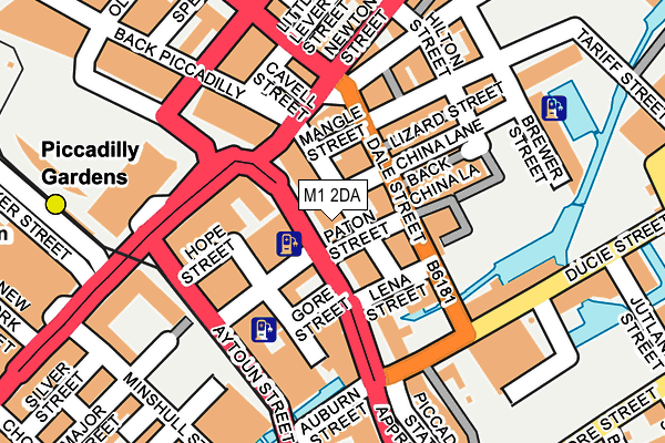
M1 2DA is located in the Piccadilly electoral ward, within the metropolitan district of Manchester and the English Parliamentary constituency of Manchester Central. The Sub Integrated Care Board (ICB) Location is NHS Greater Manchester ICB - 14L and the police force is Greater Manchester. This postcode has been in use since January 1980.


GetTheData
Source: OS OpenMap – Local (Ordnance Survey)
Source: OS VectorMap District (Ordnance Survey)
Licence: Open Government Licence (requires attribution)
| Easting | 384602 |
| Northing | 398195 |
| Latitude | 53.480249 |
| Longitude | -2.233487 |
GetTheData
Source: Open Postcode Geo
Licence: Open Government Licence
| Country | England |
| Postcode District | M1 |
| ➜ M1 open data dashboard ➜ See where M1 is on a map ➜ Where is Manchester? | |
GetTheData
Source: Land Registry Price Paid Data
Licence: Open Government Licence
Elevation or altitude of M1 2DA as distance above sea level:
| Metres | Feet | |
|---|---|---|
| Elevation | 40m | 131ft |
Elevation is measured from the approximate centre of the postcode, to the nearest point on an OS contour line from OS Terrain 50, which has contour spacing of ten vertical metres.
➜ How high above sea level am I? Find the elevation of your current position using your device's GPS.
GetTheData
Source: Open Postcode Elevation
Licence: Open Government Licence
| Ward | Piccadilly |
| Constituency | Manchester Central |
GetTheData
Source: ONS Postcode Database
Licence: Open Government Licence
| May 2022 | Violence and sexual offences | On or near Portland Street | 452m |
| March 2022 | Anti-social behaviour | On or near Supermarket | 447m |
| January 2022 | Other crime | On or near Gold Street | 286m |
| ➜ Get more crime data in our Crime section | |||
GetTheData
Source: data.police.uk
Licence: Open Government Licence
| Piccadilly/Paton St (Piccadilly) | Manchester City Centre | 18m |
| Piccadilly/Newton St (Piccadilly) | Manchester City Centre | 30m |
| Piccadilly/Paton St (Piccadilly) | Manchester City Centre | 45m |
| Piccadilly/Chatham St (Piccadilly) | Manchester City Centre | 49m |
| Piccadilly/Portland St (Piccadilly) | Manchester City Centre | 59m |
| Piccadilly Gardens (Manchester Metrolink) (Portland Street) | Piccadilly Gardens | 204m |
| Piccadilly (Manchester Metrolink) (London Road) | Manchester City Centre | 351m |
| Market Street (Manchester Metrolink) (Market Street) | Manchester City Centre | 419m |
| Shudehill (Manchester Metrolink) (Shudehill) | Manchester City Centre | 623m |
| St Peters Square (Manchester Metrolink) (Peter Street) | Manchester City Centre | 679m |
| Manchester Piccadilly Station | 0.4km |
| Manchester Oxford Road Station | 0.9km |
| Manchester Victoria Station | 1km |
GetTheData
Source: NaPTAN
Licence: Open Government Licence
| Median download speed | 14.1Mbps |
| Average download speed | 11.8Mbps |
| Maximum download speed | 22.19Mbps |
| Median upload speed | 0.9Mbps |
| Average upload speed | 0.9Mbps |
| Maximum upload speed | 1.00Mbps |
GetTheData
Source: Ofcom
Licence: Ofcom Terms of Use (requires attribution)
GetTheData
Source: ONS Postcode Database
Licence: Open Government Licence


➜ Get more ratings from the Food Standards Agency
GetTheData
Source: Food Standards Agency
Licence: FSA terms & conditions
| Last Collection | |||
|---|---|---|---|
| Location | Mon-Fri | Sat | Distance |
| Piccadilly Gardens | 19:00 | 248m | |
| Opp Woolworths Piccadilly | 19:00 | 12:00 | 257m |
| Minishull Street | 19:00 | 12:00 | 261m |
GetTheData
Source: Dracos
Licence: Creative Commons Attribution-ShareAlike
| Facility | Distance |
|---|---|
| Energie Fitness (Manchester Piccadilly) (Closed) Piccadilly, Manchester Health and Fitness Gym, Studio | 44m |
| Le Petit Spa (Manchester) Piccadilly, Manchester Health and Fitness Gym | 111m |
| Just Gym (Manchester) (Closed) Portland Street, Manchester Health and Fitness Gym, Swimming Pool | 118m |
GetTheData
Source: Active Places
Licence: Open Government Licence
| School | Phase of Education | Distance |
|---|---|---|
| Thompsons Academy trading as Navigators 1202, 61 Houldsworth Street, Manchester, M1 2FB | Not applicable | 369m |
| Co-Op Academy New Islington 10 Hugh Oldham Way, New Islington Marina, Ancoats, Manchester, M4 6EY | Primary | 611m |
| Abbey College Manchester 5-7 Cheapside, Off King Street, Manchester, M2 4WG | Not applicable | 715m |
GetTheData
Source: Edubase
Licence: Open Government Licence
The below table lists the International Territorial Level (ITL) codes (formerly Nomenclature of Territorial Units for Statistics (NUTS) codes) and Local Administrative Units (LAU) codes for M1 2DA:
| ITL 1 Code | Name |
|---|---|
| TLD | North West (England) |
| ITL 2 Code | Name |
| TLD3 | Greater Manchester |
| ITL 3 Code | Name |
| TLD33 | Manchester |
| LAU 1 Code | Name |
| E08000003 | Manchester |
GetTheData
Source: ONS Postcode Directory
Licence: Open Government Licence
The below table lists the Census Output Area (OA), Lower Layer Super Output Area (LSOA), and Middle Layer Super Output Area (MSOA) for M1 2DA:
| Code | Name | |
|---|---|---|
| OA | E00175867 | |
| LSOA | E01033653 | Manchester 055B |
| MSOA | E02006912 | Manchester 055 |
GetTheData
Source: ONS Postcode Directory
Licence: Open Government Licence
| M1 2BU | Piccadilly | 38m |
| M1 2HN | Dale Street | 66m |
| M1 2PE | Dale Street | 70m |
| M1 2HH | Dale Street | 80m |
| M1 2HS | Dale Street | 82m |
| M1 3BE | Portland Street | 97m |
| M99 1SA | Hunts Bank | 107m |
| M1 3BL | Aytoun Street | 115m |
| M1 2HF | Dale Street | 115m |
| M1 3DA | Aytoun Street | 116m |
GetTheData
Source: Open Postcode Geo; Land Registry Price Paid Data
Licence: Open Government Licence